Hierarchy
county
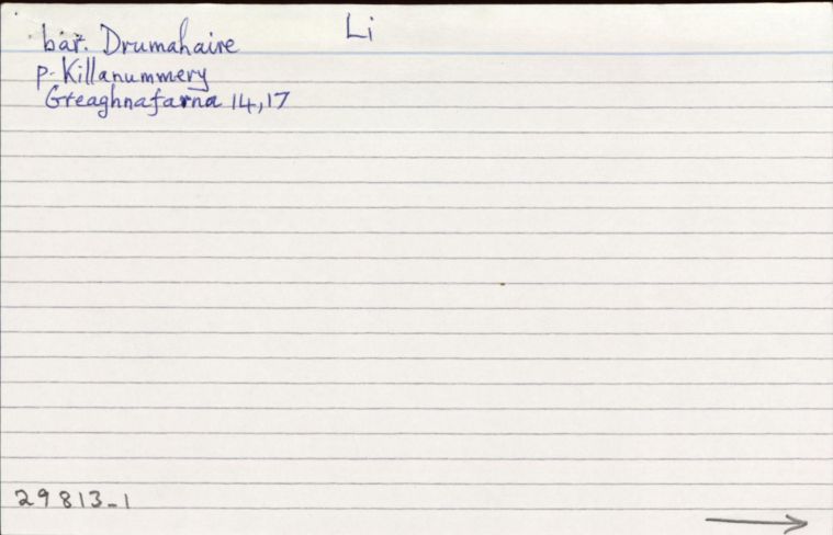
barony
civil parish
electoral division
townland
townland
Gréach na Fearna
genitive: Ghréach na Fearna
(Irish)
Greaghnafarna
(English)
Hierarchy
county
barony
civil parish
electoral division
Centrepoint
54.1716, -8.30431latitude, longitude
Irish Grid (with letter)
Computing...
Irish Grid (without letter)
Computing...
Irish Transverse Mercator (ITM)
Computing...
Archival records
Historical references
| n/a |
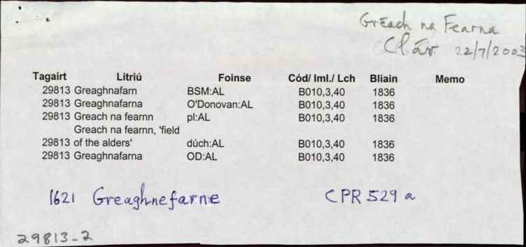
"Pinkman: Gréach-na-Feárna = Mountain flat of the alder. "
|
|
|
"Arch. Inventory: Rath. At the bottom of the W-facing slope of Blast Hill (95-6). Rath. On top of Blast Hill (96). "
|
||
| 1835 |
"Upper Greaghnafarna Lower Greaghnafarna"
|
TAB Leathanach: Innéacs, 41 (60:16/6)
|
| 1835 |
Greaghnafarna
Léarscáil: Fox
|
TAB Leathanach: (60:16/6)
|
| 1836 |
Greaghnafarn
|
|
| 1836 |
Greaghnafarna
|
|
| 1836 |
Greach na fearnn
|
|
| 1836 |
Greach na fearnn
'field of the alders'
|
|
| 1836 |
Greaghnafarna
|
|
| 2003 |
Gréach na Fearna
Le haghaidh CLÁR
|
Please note: Some of the documentation from the archives of the Placenames Branch is available here. It indicates the range of research contributions undertaken by the Branch on this placename over the years. It may not constitute a complete record, and evidence may not be sequenced on the basis of validity. It is on this basis that this material is made available to the public.
Archival and research material provided on this site may be used, subject to acknowledgement. Issues regarding republication or other permissions or copyright should be addressed to logainm@dcu.ie.
Permanent link
https://www.logainm.ie/29813.aspxOpen data
Application programming interface (API)
Available under
Creative Commons Attribution 4.0 International (CC BY 4.0)
API key required to access data
Linked Logainm
Formats: RDF | RDF N3 | RDF JSON | RDF XML
Operated by Digital Repository of Ireland