Hierarchy
county
barony
civil parish
townland
subunits
townland
Gulladoo
(English)
Hierarchy
county
barony
civil parish
Centrepoint
53.9445, -7.61994latitude, longitude
Irish Grid (with letter)
Computing...
Irish Grid (without letter)
Computing...
Irish Transverse Mercator (ITM)
Computing...
Archival records
Historical references
|
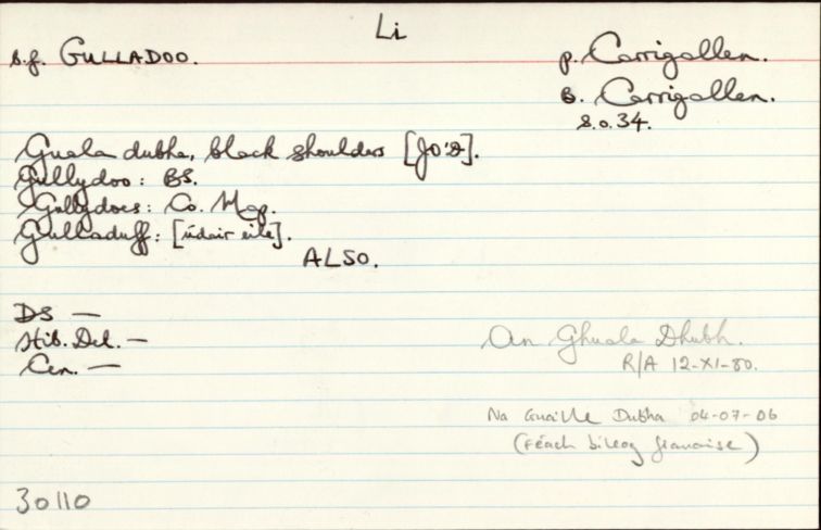
" Cf. Gulladoo, DG, p: Moville Lower, b: Inishowen East Na Guaille Dubha (1981) Gulladoo, TE, p: Donacavey, b: Omagh East "
|
||
|
"Arch. Inventory: Drumbreanlis/Gulladoo “Crannóg. Close to the SE shore of the N part…of Gulladoo Lough…near the mouth of the Cullies River where it dlows into the lake. Submerged area…defined by a series of large hewn timber posts…mostly lying prone. The centre is of stone.” (lch 45-6) “Rath. At the crest of the S end of a drumlin ridge.” (96) “Rath. One the S-facing slope of a drumlin.” (96) "
|
||
| n/a |
"Pinkman: Guala-Dubha = Black shoulders (hills). This is in the south east end of Carrigallen Parish. The shoulders are two hills on the north and south of the lake there – 319 and 281 feet high. On a day that is not too bright one may easily see how descriptive the name is. "
|
|
| 1655 |
Sissiaghnegawle
|
|
| 1660c |
Sessiagnigowle
|
BSD Leathanach: 3
|
| 1667 |
Sessiaghnegouly alias Sessiaghnegoule
|
ASE Leathanach: 101:23
|
| 1685 |
Sessanegall
|
|
| 1817 |
Gullydoes
|
|
| 1821 |
Guladuff or Sesianagowl
|
Cen. 1821 (Carrigallen) Leathanach: 115
|
| 1830c |
Sessiaghnagole (Gulliduff)
|
TAB Leathanach: (61:16/15) innéacs
|
| 1830c |
Sessiaghnagole (or Gulladuff)
|
TAB Leathanach: (61:16/15) 19,20,21
|
| 1836 |
Gullydoo
|
|
| 1836 |
Guall dubh,
'black coals'
|
|
| 1836 |
Guaile dubh,
'black coals'
|
|
| 1836 |
Gullydoes
|
|
| 1836 |
Gullydoo
|
BS:AL Nóta: (cóipleabhar)
|
| 1836 |
Gulladuff
|
|
| 1836 |
Gulladuff
|
|
| 1836 |
Gulladoo
|
|
| 1836 |
Guala dubha
'black shoulders'
|
|
| 1836 |
Gulladoo
|
|
| 1836 |
Gulladuff
|
Please note: Some of the documentation from the archives of the Placenames Branch is available here. It indicates the range of research contributions undertaken by the Branch on this placename over the years. It may not constitute a complete record, and evidence may not be sequenced on the basis of validity. It is on this basis that this material is made available to the public.
Archival and research material provided on this site may be used, subject to acknowledgement. Issues regarding republication or other permissions or copyright should be addressed to logainm@dcu.ie.
Permanent link
https://www.logainm.ie/30110.aspxOpen data
Application programming interface (API)
Available under
Creative Commons Attribution 4.0 International (CC BY 4.0)
API key required to access data
Linked Logainm
Formats: RDF | RDF N3 | RDF JSON | RDF XML
Operated by Digital Repository of Ireland