Hierarchy
county
barony
civil parish
townland
townland
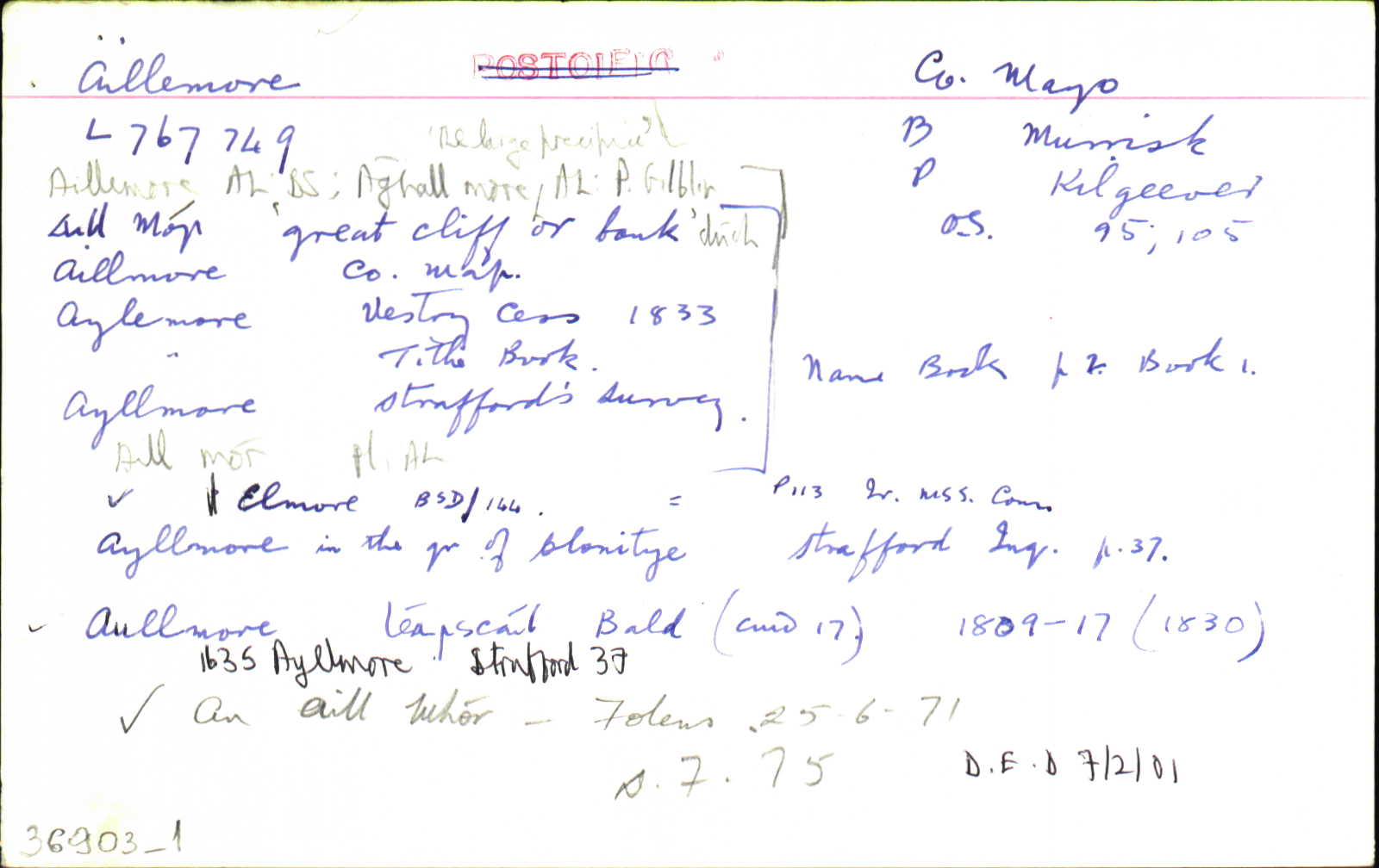
Aillemore
(English)
Centrepoint
53.702, -9.87304latitude, longitude
Irish Grid (with letter)
Computing...
Irish Grid (without letter)
Computing...
Irish Transverse Mercator (ITM)
Computing...
Archival records
Historical references
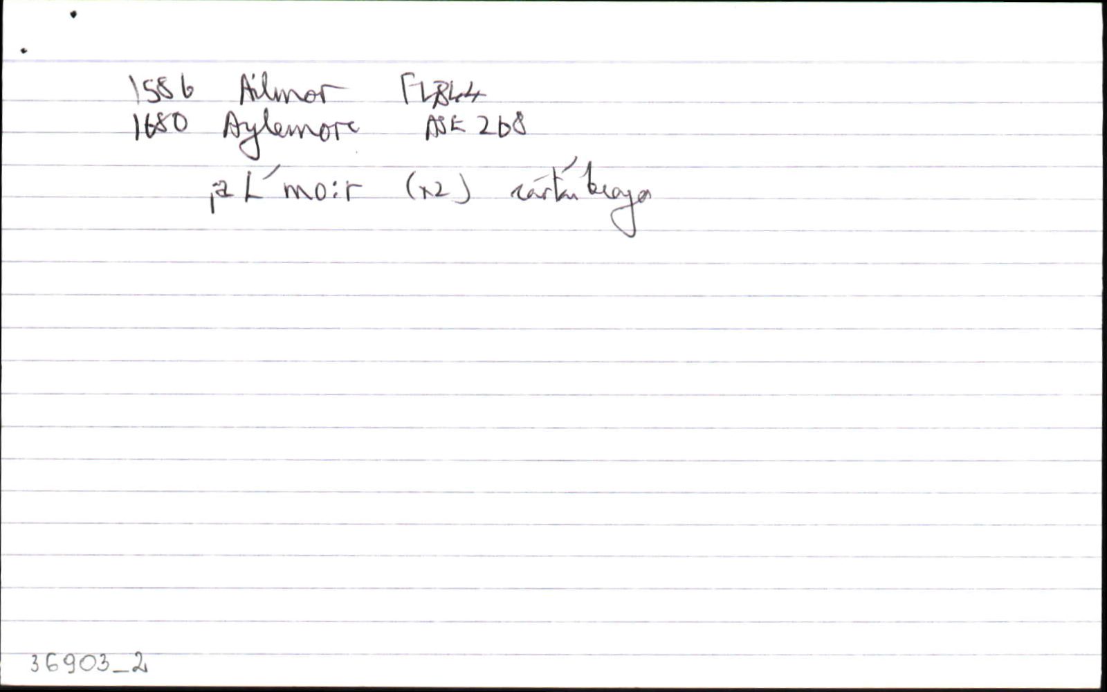
| 1585 |
Ailmor
|
F Leathanach: 4844
|
| 1635 |
½ qr of Ayllmore in the qr of Clonitye
|
Straff. Inq. ME Leathanach: §49V
|
| 1661 |
Elmore ½ a qr.
|
BSD (ME) Leathanach: 113
|
| 1677 |
Aylmore
|
Westport Est. Pap. Leathanach: 40,886/2(1)
|
| 1680 |
Aylemore
|
ASE Leathanach: 268.14
|
| 1681 |
Ellmore ½ qr.
|
ASE Leathanach: 272.33
|
| 1698 |
Ailmore 1 qr
|
Browne's RR Leathanach: 1698
|
| 1699 |
Aylemore 1 qr
|
Browne's RR Leathanach: 1699
|
| 1708 |
Aylmore
|
CGn. Imleabhar: 2.458.566
|
| 1708c |
Aylemore
|
Browne’s Lands Leathanach: I
|
| 1708c |
Aylmore
|
Browne’s Lands Leathanach: II
|
| 1710c |
Elmore
|
CRL Leathanach: 2A.3.16, 86
|
| 1792 |
Ellmore
|
QRL Leathanach: 2A.6.74, 172
|
| 1800 |
Aylemore
|
Sligo RR Leathanach: IV/1
|
| 1802 |
Aylemore
|
Browne's RR Leathanach: 1802
|
| 1812 |
Aullmore
|
|
| 1818 |
Aylemore
|
Sligo RR Leathanach: 1818
|
| 1830 |
Aullmore
|
Bald Uimhir: 17
|
| 1833 |
Aylemore
|
Browne's RR Leathanach: 1833
|
| 1838 |
Aillemore
|
BS:AL Leathanach: ME088,2
|
| 1838 |
Aullmore
|
CM:AL Leathanach: ME088,2
|
| 1838 |
Allmore & Cloonty
|
HCSV:AL Leathanach: ME088,2
|
| 1838 |
Aylemore
|
Cess 1833:AL Leathanach: ME088,2
|
| 1838 |
Aylemore
|
TAB Leathanach: ME088,2
|
| 1838 |
Aghall more, 'or the large precipice'
|
Giblin, P.:AL Leathanach: ME088,2
|
| 1838 |
Aillemore
[Rent Office, Westport]
|
Rent Office:AL (ME) Leathanach: ME088,2
|
| 1838 |
Ayllmore
|
Strafford:AL Leathanach: ME088,2
|
| 1838 |
Aill mór, 'great cliff or bank'
|
OD:AL Leathanach: ME088,2
|
| 1838 |
Aill mór
|
pl:AL Leathanach: ME088,2
|
| 1838 |
Aillemore
"Almore" "Compare all the 'aills'." [Nóta OD]
|
OD:AL Leathanach: ME088,2
|
| 1838 |
[Aillemore]
"…1 fort near N. E. corner, a Druid's Altar near the centre of this townland."
|
Desc. Rem.:AL Leathanach: ME088,2
|
Please note: Some of the documentation from the archives of the Placenames Branch is available here. It indicates the range of research contributions undertaken by the Branch on this placename over the years. It may not constitute a complete record, and evidence may not be sequenced on the basis of validity. It is on this basis that this material is made available to the public.
Archival and research material provided on this site may be used, subject to acknowledgement. Issues regarding republication or other permissions or copyright should be addressed to logainm@dcu.ie.
Permanent link
https://www.logainm.ie/36903.aspxFurther information about this place
Open data
Application programming interface (API)
Available under
Creative Commons Attribution 4.0 International (CC BY 4.0)
API key required to access data
Linked Logainm
Formats: RDF | RDF N3 | RDF JSON | RDF XML
Operated by Digital Repository of Ireland