Hierarchy
county
barony
civil parish
townland
townland
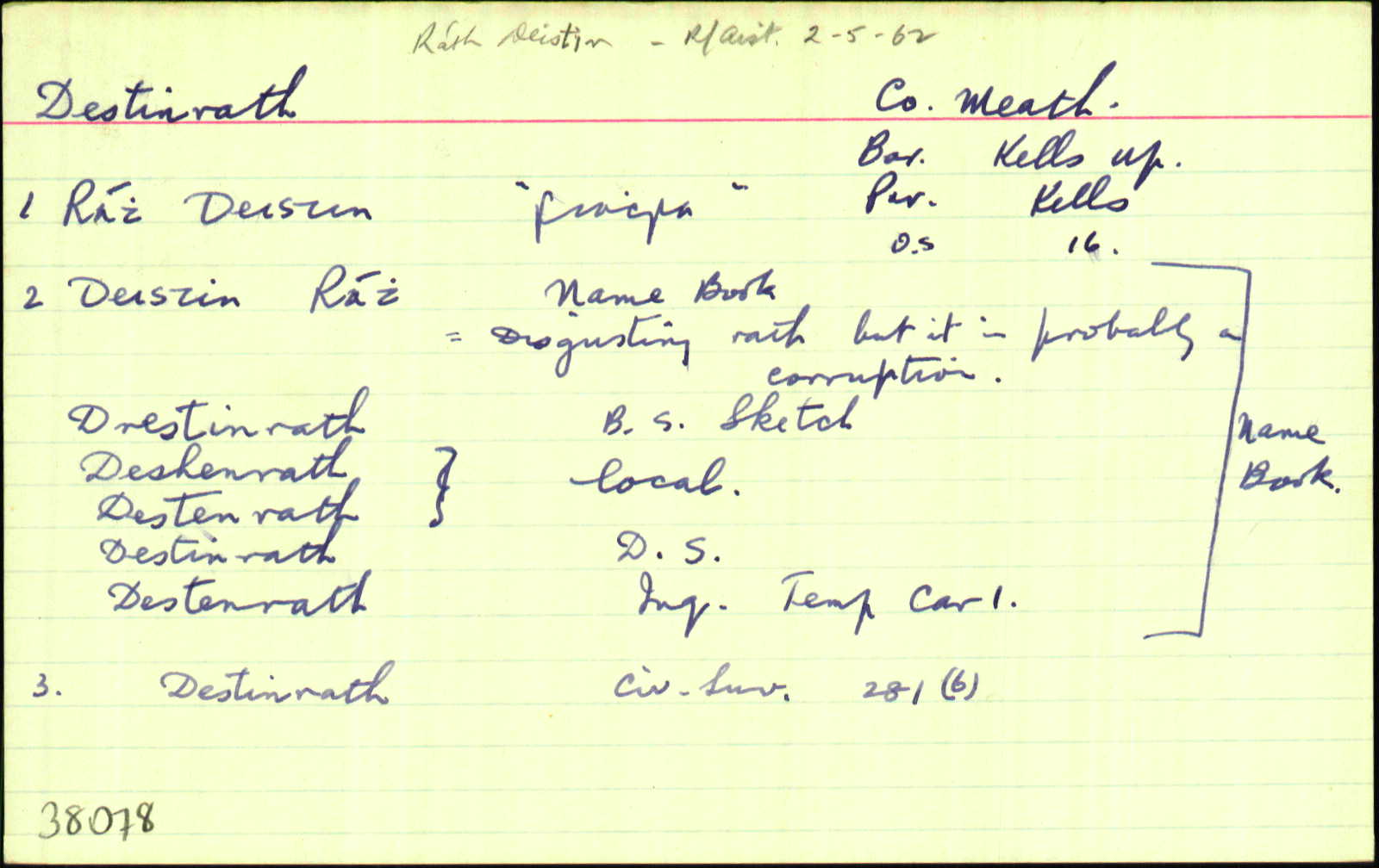
Destinrath
(English)
Hierarchy
county
barony
civil parish
Centrepoint
53.7237, -6.92078latitude, longitude
Irish Grid (with letter)
Computing...
Irish Grid (without letter)
Computing...
Irish Transverse Mercator (ITM)
Computing...
Archival records
Historical references
| 1550 |
Tystenrath
|
|
| 1638 |
Destenrath
Gerrald’ Pluncket de Drombaragh pcell’ ter’ vocat’ Skurlog’s land, Gerrald’ Pluncket, in mortag’, de vil…de Moate, Curragh, Rathenrick, Cabragh, Cornesanse & Loghan…qu’ tenuit a Gerrald’ Mape de Maperath…vil’…de Destenrath…
Maner’ de Killallon, Tulchanoge, Clonmaduffe & Kilsker… maner’ de Rathregan…in Moate, Curragh, rathenrick, Cabragh, Cornesanse, Loghan, Drumbaragh, Scurlog’s land & [ ] Inq.CI 137
|
|
| 1654 |
Destinrath
279
|
|
| 1654 |
Destinrath
Edw. Plunkett & James Plunkett Irish Papists. <br>
Bounded on the East with Callinghtown and Kells on the West & North with the lands of Drumbarah and on the South with the lands of Boolis. CS V 281
|
|
| 1654 |
Distinrath
287
|
|
| 1655-7 |
Destinrath
|
|
| 1660c |
Destinrath
Edw. Plunkett Ir. P. <br> James Plunkett I.p. 73
|
|
| 1668 |
Distinrath
27. Major BENJAMIN WOODWARD. - Drombarrogh alias Drombarrow, 300 a…more in Drombarrogh…Distinrath, part joining to Drombarrow, 172 a….Newrath, 138 a. 2r.; bar. Kells… ASE 184
|
|
| 1669c |
Destenrath
Bert or Thomas Thornhill…Part of Cnrragh [sic] and Clontenan, 127a…Destenrath, 36a… ASE 198
|
|
| 1685c |
Destinrath
|
|
| 1836 |
Destenrath
|
BS:AL Leathanach: Mí047,9
|
| 1836 |
Drestinrath
|
HCSV:AL Leathanach: Mí047,9
|
| 1836 |
Destenrath
|
Woodward:AL Leathanach: Mí047,9
|
| 1836 |
Destinrath
|
Agent & Cess Coll. (Dyas):AL Leathanach: Mí047,9
|
| 1836 |
Deshenrath; Deslenrath
|
Local:AL Leathanach: Mí047,9
|
| 1836 |
Destinrath
|
DS:AL Leathanach: Mí047,9
|
| 1836 |
Destenrath
|
Inq. C I:AL Leathanach: Mí047,9
|
| 1836 |
Deistin rath, 'disgusting rath'
"(But it is probably a corruption.)" [Nóta OD]
|
OD:AL Leathanach: Mí047,9
|
| 1836 |
Destinrath
|
OD:AL Leathanach: Mí047,9
|
| 1836 |
Destenrath
|
Larkin (Mí):AL Leathanach: Mí047,9
|
Please note: Some of the documentation from the archives of the Placenames Branch is available here. It indicates the range of research contributions undertaken by the Branch on this placename over the years. It may not constitute a complete record, and evidence may not be sequenced on the basis of validity. It is on this basis that this material is made available to the public.
Archival and research material provided on this site may be used, subject to acknowledgement. Issues regarding republication or other permissions or copyright should be addressed to logainm@dcu.ie.
Permanent link
https://www.logainm.ie/38078.aspxOpen data
Application programming interface (API)
Available under
Creative Commons Attribution 4.0 International (CC BY 4.0)
API key required to access data
Linked Logainm
Formats: RDF | RDF N3 | RDF JSON | RDF XML
Operated by Digital Repository of Ireland