Hierarchy
county
barony
civil parish
townland
townland
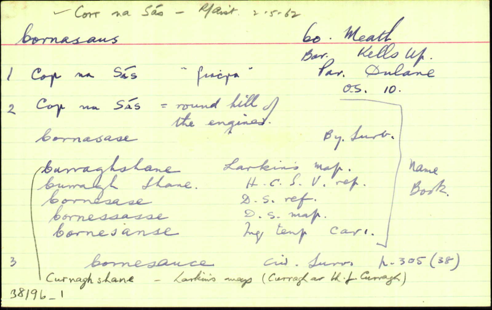
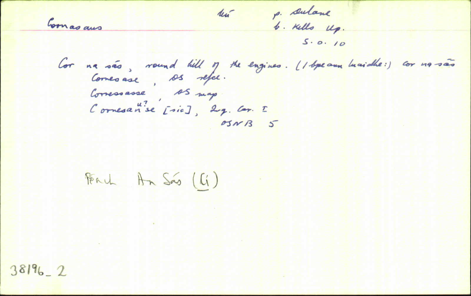
Cornasaus
(English)
Hierarchy
county
barony
civil parish
Centrepoint
53.7656, -6.94008latitude, longitude
Irish Grid (with letter)
Computing...
Irish Grid (without letter)
Computing...
Irish Transverse Mercator (ITM)
Computing...
Archival records
Historical references
| 1591 |
?Cornesaske (Donyl Reily)
Pardon to ...
<br> Donyl Beily, of Curnesaske ... F 5560
|
|
| 1637 |
Cornesanse
Jac’ Mape, nup de Maperath, seis’ fuit …vil’… de Maperath, unde hamlet’ vocat’ le Mountaynepole…120 acr’, Cabragh…Moate, Curragh, Rahenrick, Cornesanse, Loghan & Bardynagh… obit 40 an’ elaps. Gerrald’ Mape est ejus fil’ & her’…fuit etat’ 3 annor’ tempore mortis pris sui, & non maritat’ Inq.CI 139
|
|
| 1638 |
Cornesanse
Gerrald’ Pluncket de Drombaragh pcell’ ter’ vocat’ Skurlog’s land, Gerrald’ Pluncket, in mortag’, de vil…de Moate, Curragh, Rathenrick, Cabragh, Cornesanse & Loghan…qu’ tenuit a Gerrald’ Mape de Maperath…vil’…de Destenrath…
Maner’ de Killallon, Tulchanoge, Clonmaduffe & Kilsker… maner’ de Rathregan…in Moate, Curragh, rathenrick, Cabragh, Cornesanse, Loghan, Drumbaragh, Scurlog’s land & [ ] Inq.CI 137
|
|
| 1654 |
Cornecause
Cabragh...<br>
Bounded ...on the South with the Mote, Cornecause, Curragh, & Clonfonan. CS V 303
|
|
| 1654 |
Cornesauce (The Mote, Cornesauce, Curragh & Clonfanan) <br> Corne Sause.
Gerrald Mape of Maperath, Irish Papist. <br>
Bounded on the east with the lands of Maperath & Bardanagh, on the west with Rathenrick, on the North with Cabragh, & on the south with the lands of Rathbracke.
CS V 305
|
|
| 1655-7 |
Cornesasse
|
|
| 1660c |
Cornesase
Garrett Mape. 87.
|
|
| 1663 |
Cornasane
Gerrald’ Mapp nup fuit…praetor…de Mapprath, in pocia de Loghane…Muntainepole in poch’ de Kells…Mote in …de Dulane, Cornasane, Curra[], Clonfennan. <Br> Inq.CII 3
|
|
| 1669c |
Cornelasse or Cornesalse
RICHARD STEPHENS esq. Cornelasse or Cornesalse,
190 a. or 192a…bar. Kells, co. Meath. ASE 219
|
|
| 1714 |
Cornesasse
(Taylor-Melville) the White Commons, the Nine Acres, Sheenies, Tatteragh, Mullaghy, Balrask, Burfordstowne, Brownstown & Rathmore, Irishtowne, Lackmelch, Pepperstown, Calliaghtown, Maperath, Mountain Pole & Rochford’s Land, Upper & Lower Rebrack, Curragh, Cornesasse, Clounfinon, Horath, Armagh, Ballintillon, Curraghstown, Newrath, Mote, Croskelly, (Morgallion & Kells) Corrstown (Kells) Drumbarrow, parishes of Stonehall, Castlekeran, Loughan & Dervey CGn. 34.9.20189
|
|
| 1836 |
Curnagh Shane
|
HCSV:AL Leathanach: Mí035,5
|
| 1836 |
Cornasase
|
BS:AL Leathanach: Mí035,5
|
| 1836 |
Curnagh shane
|
Larkin (Mí):AL Leathanach: Mí035,5
|
| 1836 |
Cornasase
|
Sargent, Rev. R.:AL Leathanach: Mí035,5
|
| 1836 |
Curnasase
|
Agent & Cess Coll. (Dyas):AL Leathanach: Mí035,5
|
| 1836 |
Cornasas
|
Local:AL Leathanach: Mí035,5
|
| 1836 |
Cornesase
|
DS Ref.:AL Leathanach: Mí035,5
|
| 1836 |
Cornessasse
|
DS Map:AL Leathanach: Mí035,5
|
| 1836 |
Cornesanse
|
Inq. C I:AL Leathanach: Mí035,5
|
| 1836 |
Cor na sás, 'round hill of the engines'
|
OD:AL Leathanach: Mí035,5
|
| 1836 |
Cor na sás
|
pl:AL Leathanach: Mí035,5
|
| 1836 |
Cornasaus
"See Leitrim index." [Nóta OD]
|
OD:AL Leathanach: Mí035,5
|
| 1836 |
AL Leathanach: Mí035,5
|
Please note: Some of the documentation from the archives of the Placenames Branch is available here. It indicates the range of research contributions undertaken by the Branch on this placename over the years. It may not constitute a complete record, and evidence may not be sequenced on the basis of validity. It is on this basis that this material is made available to the public.
Archival and research material provided on this site may be used, subject to acknowledgement. Issues regarding republication or other permissions or copyright should be addressed to logainm@dcu.ie.
Permanent link
https://www.logainm.ie/38196.aspxOpen data
Application programming interface (API)
Available under
Creative Commons Attribution 4.0 International (CC BY 4.0)
API key required to access data
Linked Logainm
Formats: RDF | RDF N3 | RDF JSON | RDF XML
Operated by Digital Repository of Ireland