Hierarchy
county
barony
civil parish
townland
townland
Curragh
(English)
Hierarchy
county
barony
civil parish
Centrepoint
53.7583, -6.95376latitude, longitude
Irish Grid (with letter)
Computing...
Irish Grid (without letter)
Computing...
Irish Transverse Mercator (ITM)
Computing...
Archival records
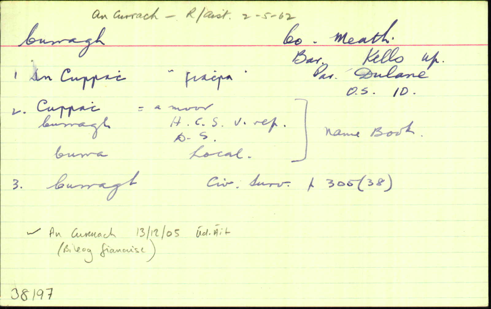
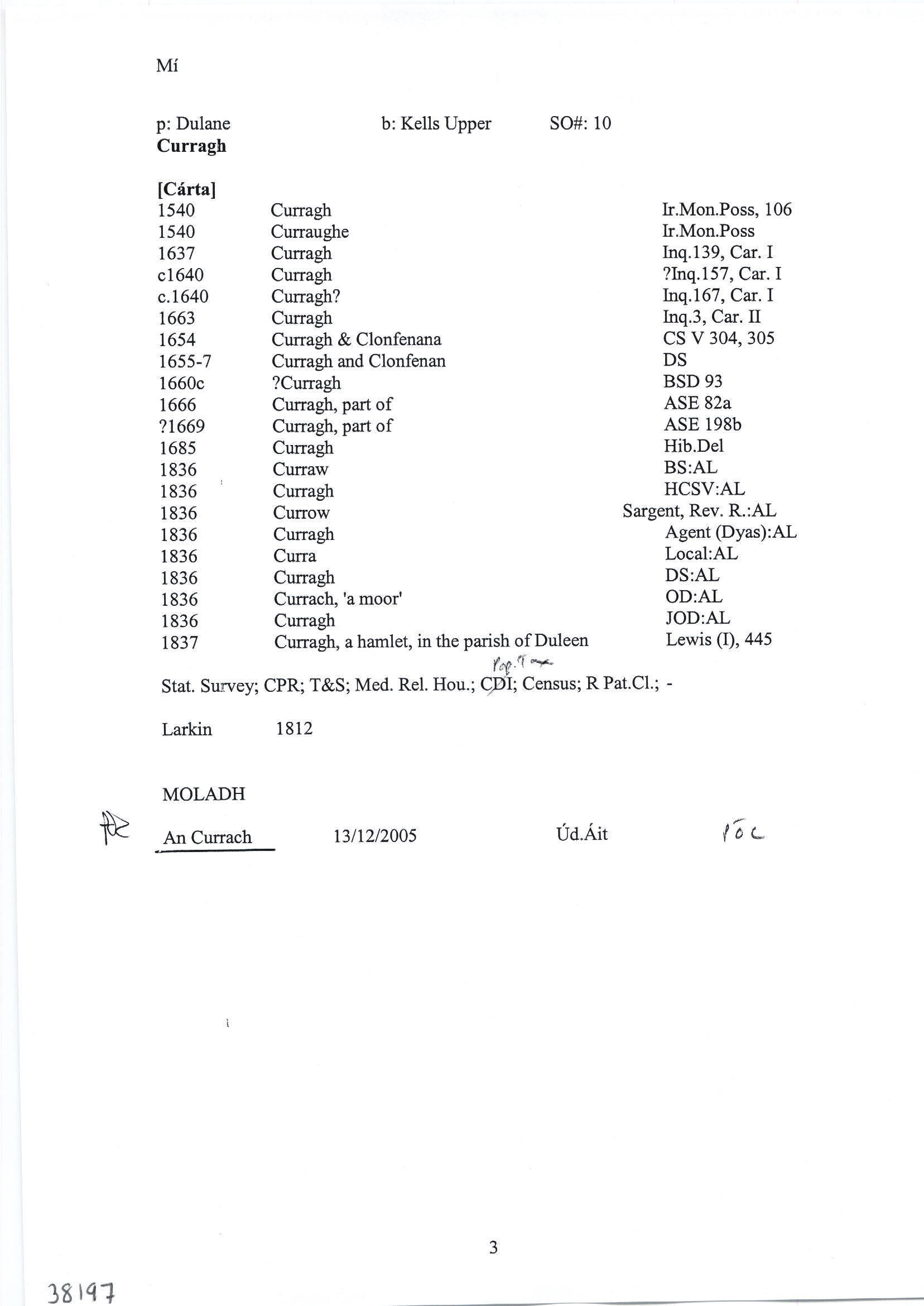
Historical references
| 1637 |
Curragh
Jac’ Mape, nup de Maperath, seis’ fuit …vil’… de Maperath, unde hamlet’ vocat’ le Mountaynepole…120 acr’, Cabragh…Moate, Curragh, Rahenrick, Cornesanse, Loghan & Bardynagh… obit 40 an’ elaps. Gerrald’ Mape est ejus fil’ & her’…fuit etat’ 3 annor’ tempore mortis pris sui, & non maritat’ Inq.CI 139
|
|
| 1638 |
Curragh
Gerrald’ Pluncket de Drombaragh pcell’ ter’ vocat’ Skurlog’s land, Gerrald’ Pluncket, in mortag’, de vil…de Moate, Curragh, Rathenrick, Cabragh, Cornesanse & Loghan…qu’ tenuit a Gerrald’ Mape de Maperath…vil’…de Destenrath…
Maner’ de Killallon, Tulchanoge, Clonmaduffe & Kilsker… maner’ de Rathregan…in Moate, Curragh, rathenrick, Cabragh, Cornesanse, Loghan, Drumbaragh, Scurlog’s land & [ ] Inq.CI 137
|
|
| 1654 |
Curragh
Cabragh
<br>
Bounded ... on the South with the Mote, Cornecause, Curragh, & Clonfonan. CS V 303
|
|
| 1654 |
Curragh (The Mote, Cornesauce, Curragh & Clonfanan)
Gerrald Mape of Maperath, Irish Papist. <br>
Bounded on the east with the lands of Maperath & Bardanagh, on the west with Rathenrick, on the North with Cabragh, & on the south with the lands of Rathbracke.
CS V 305
|
|
| 1655-7 |
Curragh & Clonfenan
|
|
| 1660c |
Curragh & Clonfenane
Garrett Mape. 87.
|
|
| 1667 |
Curragh
RICHARD STEPHENS the younger, esq.—Lawrencetowne
(part), 188 a…Maprath,254a…the Motte, 128 a…Clonfinnen and part of Curragh, 235 a…Rathbrakes, 242 a…mountain
Pole…part of Kells, lying next to the white commons of which Rochford of Killbried was proprietor, 56 a…the white commons, 37 a. several parcells of laud near Kells, with the several mills
thereon, 450 a…in Mullaghay, 51 a…Balreaske, 151 a…
bar. Kells, co. Meath.— Total quantity, 1,971 a…
Taterath,
Fyanstowne, and Hullstowne or Hurlestowne, 769 a…
ASE 82
|
|
| 1685c |
Curragh
|
|
| 1714 |
Curragh
(Taylor-Melville) the White Commons, the Nine Acres, Sheenies, Tatteragh, Mullaghy, Balrask, Burfordstowne, Brownstown & Rathmore, Irishtowne, Lackmelch, Pepperstown, Calliaghtown, Maperath, Mountain Pole & Rochford’s Land, Upper & Lower Rebrack, Curragh, Cornesasse, Clounfinon, Horath, Armagh, Ballintillon, Curraghstown, Newrath, Mote, Croskelly, (Morgallion & Kells) Corrstown (Kells) Drumbarrow, parishes of Stonehall, Castlekeran, Loughan & Dervey CGn. 34.9.20189
|
|
| 1836 |
Currach, 'a moor'
|
OD:AL Leathanach: Mí035,6
|
| 1836 |
Curraw
|
BS:AL Leathanach: Mí035,6
|
| 1836 |
Curragh
|
HCSV:AL Leathanach: Mí035,6
|
| 1836 |
Currow
|
List of Voters 1832:AL Leathanach: Mí035,6
|
| 1836 |
Currow
|
Sargent, Rev. R.:AL Leathanach: Mí035,6
|
| 1836 |
Curragh
|
Agent (Dyas):AL Leathanach: Mí035,6
|
| 1836 |
Curra
|
Local:AL Leathanach: Mí035,6
|
| 1836 |
Curragh
|
DS:AL Leathanach: Mí035,6
|
| 1836 |
Curragh
|
OD:AL Leathanach: Mí035,6
|
Please note: Some of the documentation from the archives of the Placenames Branch is available here. It indicates the range of research contributions undertaken by the Branch on this placename over the years. It may not constitute a complete record, and evidence may not be sequenced on the basis of validity. It is on this basis that this material is made available to the public.
Archival and research material provided on this site may be used, subject to acknowledgement. Issues regarding republication or other permissions or copyright should be addressed to logainm@dcu.ie.
Permanent link
https://www.logainm.ie/38197.aspxOpen data
Application programming interface (API)
Available under
Creative Commons Attribution 4.0 International (CC BY 4.0)
API key required to access data
Linked Logainm
Formats: RDF | RDF N3 | RDF JSON | RDF XML
Operated by Digital Repository of Ireland