Hierarchy
county
barony
civil parish
electoral division
townland
townland
Balreask
(English)
Hierarchy
county
barony
civil parish
electoral division
Centrepoint
53.7524, -6.82999latitude, longitude
Irish Grid (with letter)
Computing...
Irish Grid (without letter)
Computing...
Irish Transverse Mercator (ITM)
Computing...
Archival records
Historical references
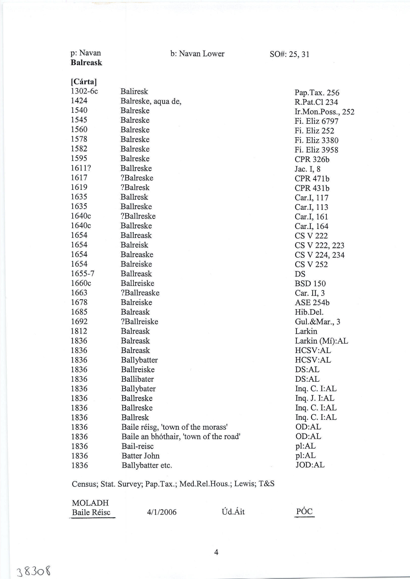
| 1582 |
Balreske
Pardon to Walter Betaghe fitz James, of Rathdrommogh,
co. Meath, gent,, Hugh m'Shane O Relye, of Maghemorie,
and Thady M'Brene, of Corraghton, same co. horsemen, Phelim
M'Shane, of Droneschell, Tho. m'Donagh M'Bren, late of same,
Fersie m'Shane boie M'Bren, of Feaghe, Ouen M'Bren, of Newcastell,
Tirlaghe m'Shane M'Bren, of same, Wm. Duffe M'Shaffrie, of Feaghe, Edm. grome M'Donghe, of Kilemynche,
Edm. galte M'Dun, of same, Rowry M'Bren, of Balreske, Tho.
duffe M'Bren, of Raurie, Patr. m'Ardille M'Bren, of Newcastell,
and Patr. M'Gergane, of Moibolge, in said co., kerns. F 3958
|
|
| 1624 |
Balrieske
Castleton de Moore, Fresselstown, Cravelston…Dunapatricke…Balrieske…(Rob. Dillon) …Plunkett de Gibston… Inq.JI 69
|
|
| 1627 |
Ballreske & Litleresk
Christ’ Plunckett …de Knockglass & Mahonstowne…
Ballentlewe & Ballentarsen sunt pcell’ vil’ de Dooneoure….Knockglasse & Mahonstowne… 60acr’ in Newton.
Vil’ & ter de Ballreske & Ballentlew…non pcell’ …de Donowre….de Ballentarsen, Ballentlew, Ballreske & Littleresk tenent’ ut de maner’ de Kells… Donoure, Knockglasse & Mahonstowne…Dooleene…xravellston. Inq.CI 29
|
|
| 1654 |
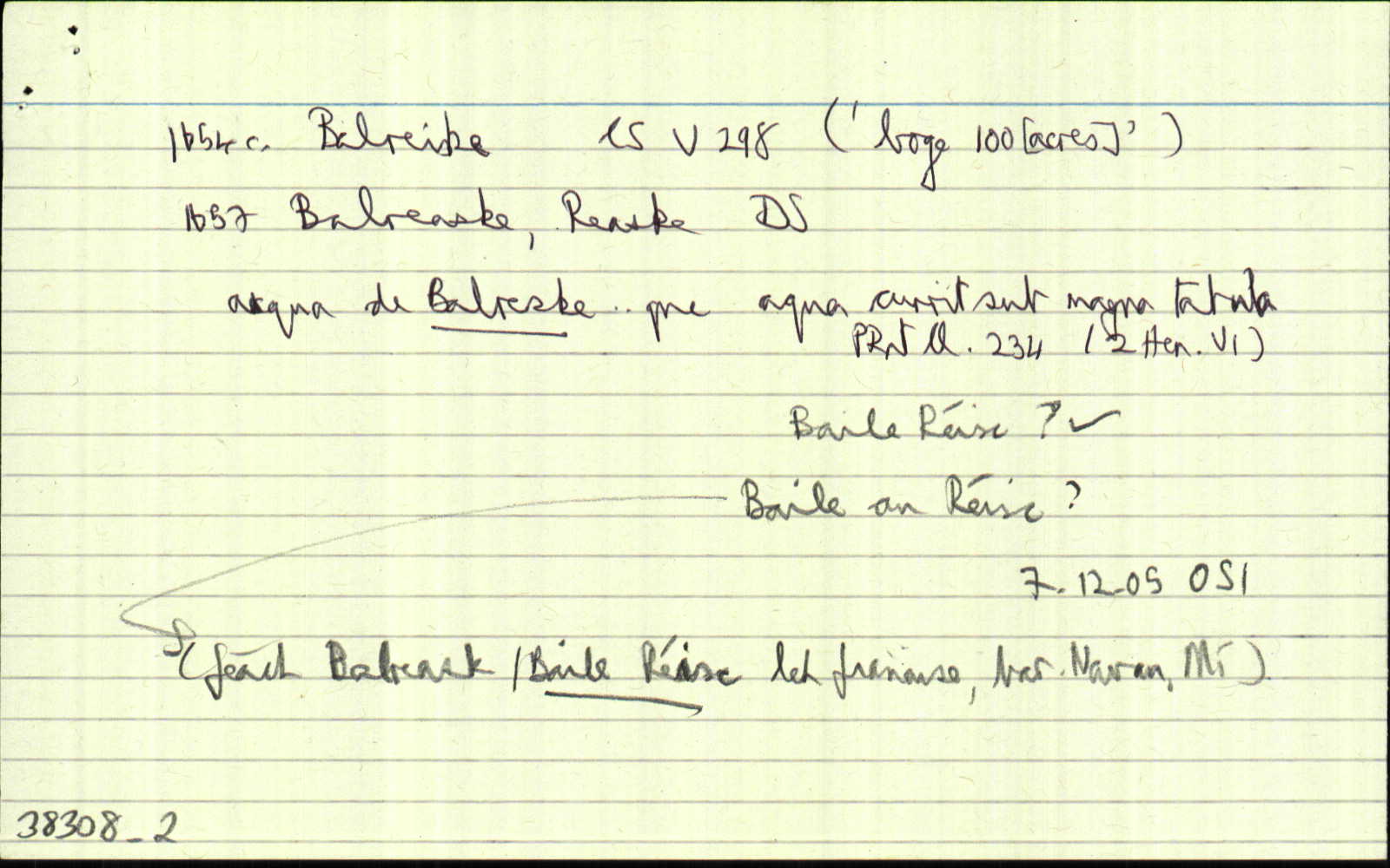
Balreiske, Balrisk
William Betah of Donowre, Irish Papist. <br>
Bounded on the East with Emlough, on the west with Norbinstowne, on the North with…Reiske & on the South with Grange Rossmyne. CS V 298
|
|
| 1655-7 |
Balreaske
|
|
| 1655-7 |
Balreask
William Betagh of Donore Ir: papst.
|
|
| 1660c |
Ballreaske
Wm. Betagh, Ir. pa. 85.
|
|
| 1663 |
Ballreaske
Wm. Betagh …Ballreaske <br> Inq.CII 3
|
|
| 1667 |
Balreaske
RICHARD STEPHENS the younger, esq.—Lawrencetowne
(part), 188 a…Maprath,254a…the Motte, 128 a…Clonfinnen and part of Curragh, 235 a…Rathbrakes, 242 a…mountain
Pole…part of Kells, lying next to the white commons of which Rochford of Killbried was proprietor, 56 a…the white commons, 37 a. several parcells of laud near Kells, with the several mills
thereon, 450 a…in Mullaghay, 51 a…Balreaske, 151 a…
bar. Kells, co. Meath.— Total quantity, 1,971 a…
Taterath,
Fyanstowne, and Hullstowne or Hurlestowne, 769 a…
ASE 82
|
|
| 1685c |
Balreask
|
|
| 1714 |
Bakrask
(Taylor-Melville) the White Commons, the Nine Acres, Sheenies, Tatteragh, Mullaghy, Balrask, Burfordstowne, Brownstown & Rathmore, Irishtowne, Lackmelch, Pepperstown, Calliaghtown, Maperath, Mountain Pole & Rochford’s Land, Upper & Lower Rebrack, Curragh, Cornesasse, Clounfinon, Horath, Armagh, Ballintillon, Curraghstown, Newrath, Mote, Croskelly, (Morgallion & Kells) Corrstown (Kells) Drumbarrow, parishes of Stonehall, Castlekeran, Loughan & Dervey CGn. 34.9.20189
|
|
| 1828 |
Balreask
Balreask, Carrick Monks Upper & Lower.
|
|
| 1836 |
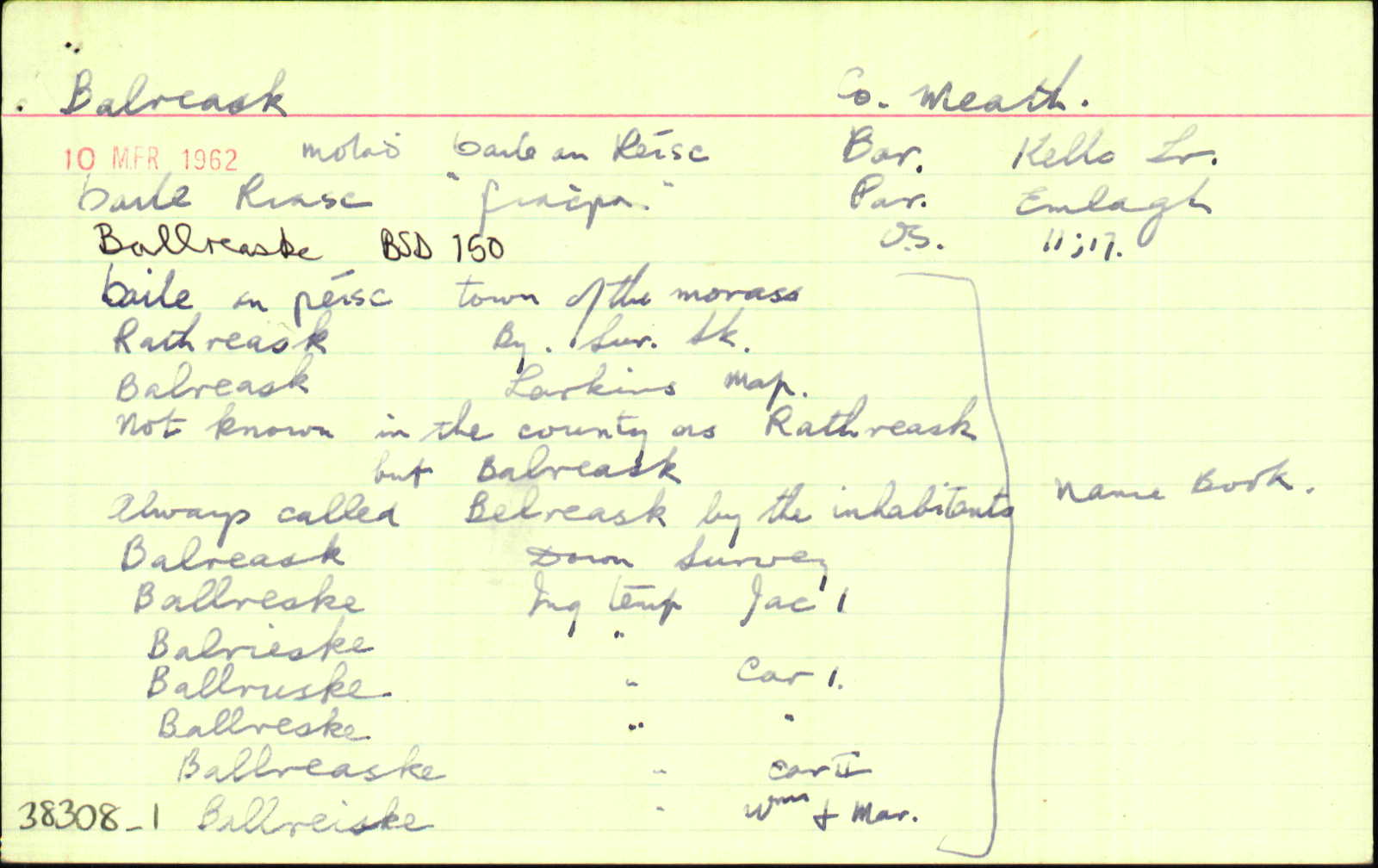
Rathreask
|
BS:AL Leathanach: Mí040,19
|
| 1836 |
Balrisk
|
GJP 1828:AL Leathanach: Mí040,19
|
| 1836 |
Ballreske
|
Inq. J I:AL Leathanach: Mí040,20
|
| 1836 |
Balrieske
|
Inq. J I:AL Leathanach: Mí040,20
|
| 1836 |
Ballruske
|
Inq. C I:AL Leathanach: Mí040,20
|
| 1836 |
Ballreske
|
Inq. C I:AL Leathanach: Mí040,20
|
| 1836 |
Ballreaske
|
Inq. C II:AL Leathanach: Mí040,20
|
| 1836 |
Ballreiske
|
Inq. G. & M.:AL Leathanach: Mí040,20
|
| 1836 |
Balreask
|
OD:AL Leathanach: Mí040,20
|
| 1836 |
Balreask
|
Larkin (Mí):AL Leathanach: Mí040,19
|
| 1836 |
Balreask
|
Headfort Estate Map 1818: Leathanach: Mí040,19
|
| 1836 |
Ballreaske
|
Bar. Cons. (Tevlin):AL Leathanach: Mí040,19
|
| 1836 |
Balreask
|
GJP 1830:AL Leathanach: Mí040,19
|
| 1836 |
Baile an réisg, 'town of the morass'
"Not known in the county as Rathreask but Balreask." [dúch]
|
OD:AL Leathanach: Mí040,19
|
| 1836 |
Ballreask
|
Co. Schedule 1830:AL Leathanach: Mí040,20
|
| 1836 |
Balreask
|
Dunn, J.:AL Leathanach: Mí040,20
|
| 1836 |
Always called Belreask
|
Inhabs.:AL Leathanach: Mí040,20
|
| 1836 |
Rathreask
|
HCSV:AL Leathanach: Mí040,20
|
| 1836 |
Balreask
|
DS:AL Leathanach: Mí040,20
|
Please note: Some of the documentation from the archives of the Placenames Branch is available here. It indicates the range of research contributions undertaken by the Branch on this placename over the years. It may not constitute a complete record, and evidence may not be sequenced on the basis of validity. It is on this basis that this material is made available to the public.
Archival and research material provided on this site may be used, subject to acknowledgement. Issues regarding republication or other permissions or copyright should be addressed to logainm@dcu.ie.
Permanent link
https://www.logainm.ie/38308.aspxOpen data
Application programming interface (API)
Available under
Creative Commons Attribution 4.0 International (CC BY 4.0)
API key required to access data
Linked Logainm
Formats: RDF | RDF N3 | RDF JSON | RDF XML
Operated by Digital Repository of Ireland