Hierarchy
county
barony
civil parish
townland
townland
Rathdrinagh
(English)
Hierarchy
county
barony
civil parish
Centrepoint
53.6622, -6.51399latitude, longitude
Irish Grid (with letter)
Computing...
Irish Grid (without letter)
Computing...
Irish Transverse Mercator (ITM)
Computing...
Archival records
Historical references
| 1540-1 |
Radrenoghe
Balragan near Donnore (Dardys, gent)
Monamore (Walt Dowdall)
|
|
| 1541 |
Radronoghe
Lease to Laurence Townley, of Dublin, gent. ; of the site of
the abbey of the B.V.M., of Mellifunt, county Louth … Oldbrige, Shepehouse, Rathmolane, Stalinge, Donore, Doo,
Glashalyn, Grangeithe, Crewodd, Balranny, Kardoragh, Ranyskyn
alias Monknewton, Newgrange, Ballyfadoke, Knoythe,
Kelliston, Cracamothan, Rosynry, Gilton, Dromynhaull, Radronoghe,
Cullyn, and Starenaghe, and a fishery of the Boyne, with
the weirs of Stalinge, Brows, Monckenwerr, and Oldbrigge,
county Meath. FHen. 254
|
|
| 1566 |
Radrenaghe
Edward Moore of Mellefont … <br>
the lands, customs and tithesof Oldbridge,a
salmon weir on the Boyne …
customs and tithes of Shepehowse, Ramollan …Stalinge … Doo, Glassehallyn,
Graungegithe, Crewood, Ballranny, Kardraghe, Ranysken alias Monckenewton, Newgraunge, with Browusweir and the fishing of
the Boyne there and Borowismill, Ballyfadock, Knoyth, Kellyston,
Cracomothan, Rossynry,with Mooncketon salmon weir, a deep pool, ;
and a mill on the Boyne, Gylton, Dromenhalle, Radrenaghe,
Cullyn, and Starenaghe, county Meath, F 889
|
|
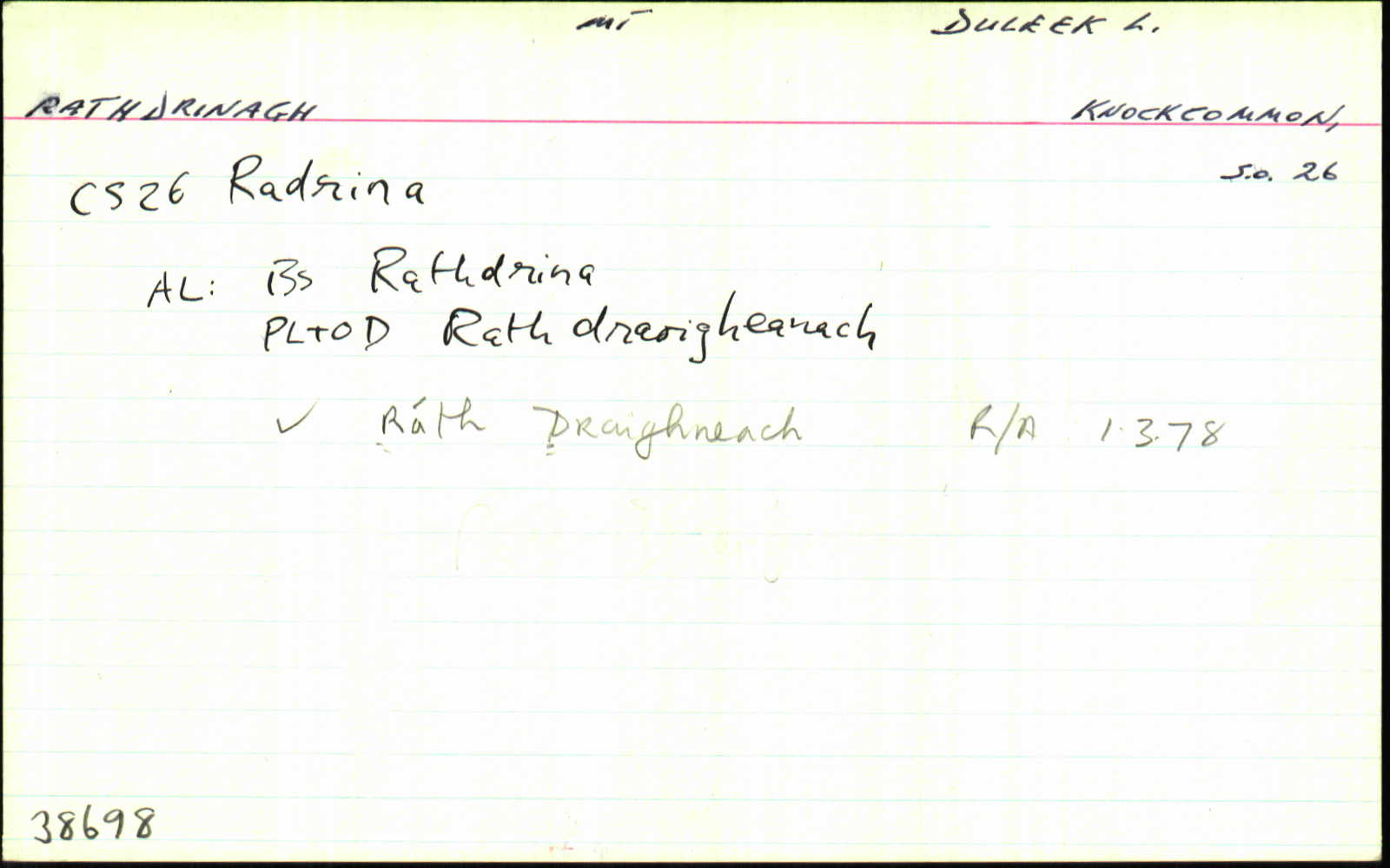
| 1836 |
Rathdrina
|
BS:AL Leathanach: Mí012,42
|
| 1836 |
Rathdrino; Rathdrina
|
CM:AL Leathanach: Mí012,42
|
| 1836 |
Raddrinagh
|
GJRates (Old Docket): AL Leathanach: Mí012,42
|
| 1836 |
Rath draoigheanach, 'rath of the sloe bushes, or black thorns'
|
OD:AL Leathanach: Mí012,42
|
| 1836 |
Rath draoigheanach, 'rath of the sloe bushes, or black thorns'
|
pl:AL Leathanach: Mí012,42
|
| 1836 |
Rathdrinagh
|
OD:AL Leathanach: Mí012,42
|
| 1836 |
Raddrinagh
|
HCSV:AL Leathanach: Mí012,42
|
Please note: Some of the documentation from the archives of the Placenames Branch is available here. It indicates the range of research contributions undertaken by the Branch on this placename over the years. It may not constitute a complete record, and evidence may not be sequenced on the basis of validity. It is on this basis that this material is made available to the public.
Archival and research material provided on this site may be used, subject to acknowledgement. Issues regarding republication or other permissions or copyright should be addressed to logainm@dcu.ie.
Permanent link
https://www.logainm.ie/38698.aspxFurther information about this place
Open data
Application programming interface (API)
Available under
Creative Commons Attribution 4.0 International (CC BY 4.0)
API key required to access data
Linked Logainm
Formats: RDF | RDF N3 | RDF JSON | RDF XML
Operated by Digital Repository of Ireland