Hierarchy
county
barony
civil parish
electoral division
townland
townland
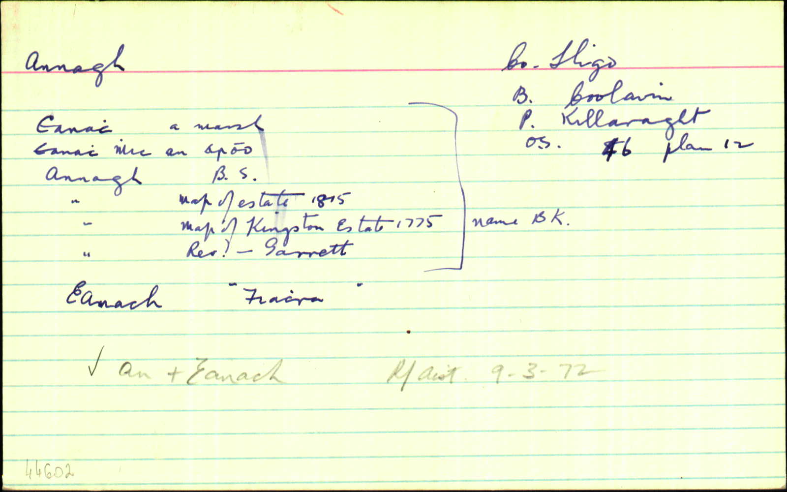
Annagh
(English)
Hierarchy
county
barony
civil parish
electoral division
Centrepoint
53.9182, -8.46199latitude, longitude
Irish Grid (with letter)
Computing...
Irish Grid (without letter)
Computing...
Irish Transverse Mercator (ITM)
Computing...
Archival records
Historical references
| n/a | ||
| n/a | ||
| n/a | ||
| 1660c |
Annaghmcannarroe
|
BSD Leathanach: 129
|
| 1719 |
Annagh
|
CGn. Leathanach: 27.77.15246
|
| 1834 |
Annagh; Annaghvicnara
|
|
| 1836 |
Annagh
|
Kingston Map 1775:AL Leathanach: Sl025,2
|
| 1836 |
Annagh
|
Garrett, Rev.:AL Leathanach: Sl025,2
|
| 1836 |
Annagh
|
OD:AL Leathanach: Sl025,2
|
| 1836 |
Eanach Mhic an Aroo/
|
pl:AL Leathanach: Sl025,2
|
| 1836 |
Eanach
|
pl:AL Leathanach: Sl025,2
|
| 1836 |
Eanach, 'a marsh'
|
OD:AL Leathanach: Sl025,2
|
| 1836 |
Eanach mhic an earabh & Eanac Bheag
|
OD:AL Leathanach: Sl025,2
|
| 1836 |
Eanach & E. Bheg
|
pl:AL Leathanach: Sl025,2
|
| 1836 |
[Annagh]
"There is a well called by inhabitants Patrick's Well in the N. side of the townland and old graveyard on the S. side where there is an alter where the people say their prayers when the preist [sic] cannot attend" [Desc. Rem.];
|
Desc. Rem.:AL Leathanach: Sl025,2
|
| 1836 |
Annagh
|
BS:AL Leathanach: Sl025,2
|
| 1836 |
Annaghbeg
|
CM:AL Leathanach: Sl025,2
|
| 1836 |
Annagh
|
Map of Estate 1815:AL Leathanach: Sl025,2
|
| 1836 |
Annagh
|
BS:AL Leathanach: Sl025,2
|
| 1836 |
Annaghmi(m)kancragh ows. Anaghmoyle
|
CGn. Leathanach: 1836.12.274.320
|
| 1836 |
Annaghbeg
|
|
| 1836 |
There is a well called by inhabitants Patrick’s Well in the N. side of the townland and old graveyard on the S. side where there is an alter where the people say their prayers when the preist [sic] cannot attend’
|
|
| 1836 |
Annagh
|
|
| 1836 |
Annagh
|
|
| 1836 |
Annagh
|
|
| 1836 |
Annagh
|
|
| 1836 |
Eanach “a marsh”
|
|
| 1836 |
Eanach mhic an earabh & Eanac Bheag
|
|
| 1836 |
Eanach
|
|
| 1836 |
Eanach & E. Bheg
|
|
| 1836 |
Eanach Mhic an Aroo/
|
|
| 1839 |
Anaghmuckaneragh ors. Anaghmoyle
|
CGn. Leathanach: 1839.14.37.354
|
| 1840 |
Anaghmackanoragh
|
CGn. Leathanach: 1840.14.34.384
|
| 1840 |
Anaghmuckaneragh ors. Anaghmoyle
|
CGn. Leathanach: 1840.6.180.164
|
| 1848 |
Annoghmuikenoragh ors. Annoghniogh
|
CGn. Leathanach: 1848.16.31.446
|
| 1849 |
Anaghmackanoragh
|
CGn. Leathanach: 1849.8.7.200
|
Please note: Some of the documentation from the archives of the Placenames Branch is available here. It indicates the range of research contributions undertaken by the Branch on this placename over the years. It may not constitute a complete record, and evidence may not be sequenced on the basis of validity. It is on this basis that this material is made available to the public.
Archival and research material provided on this site may be used, subject to acknowledgement. Issues regarding republication or other permissions or copyright should be addressed to logainm@dcu.ie.
Permanent link
https://www.logainm.ie/44602.aspxOpen data
Application programming interface (API)
Available under
Creative Commons Attribution 4.0 International (CC BY 4.0)
API key required to access data
Linked Logainm
Formats: RDF | RDF N3 | RDF JSON | RDF XML
Operated by Digital Repository of Ireland