Hierarchy
county
barony
civil parish
townland
townland
An Leathbhaile Íochtarach
genitive: an Leathbhaile Íochtaraigh
validated name (What is this?)
(Irish)
Lavally Lower
(English)
Hierarchy
county
barony
civil parish
Explanatory note
- English
the half-town
Centrepoint
52.4016, -7.78833latitude, longitude
Irish Grid (with letter)
Computing...
Irish Grid (without letter)
Computing...
Irish Transverse Mercator (ITM)
Computing...
Archival records
Historical references
| n/a |
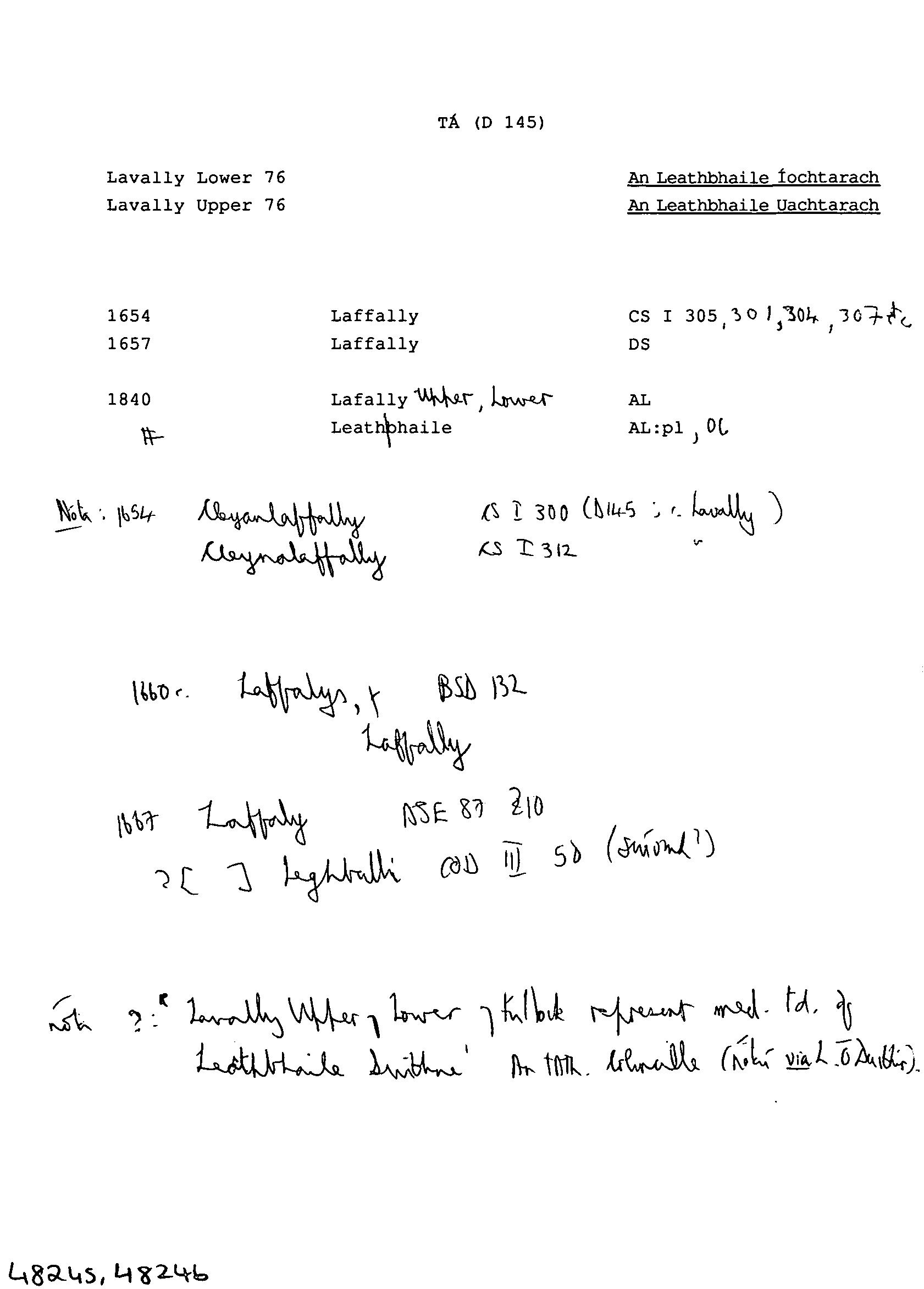
Nóta ?: 'Lavally Upper, Lower, Kulbuk represent med. Td of Leathbhaile Suibhne' An tha. Ghralle (nótaí via L. Ó Duibhir).
|
|
| n/a | ||
| n/a |
Nóta: 1654 Cleyanlaffally CS I 300 (D145; Lavally)
|
|
| c 1428 |
Leghballi
|
COD Leathanach: III. 50
|
| 1654 |
Laffally
|
CS I Leathanach: 305, 301, 304 307 etc
|
| 1657 |
Laffally
|
|
| c.1660 |
Laffally
|
BSD (TÁ) Leathanach: 132
|
| c.1660 |
Laffalyn
|
BSD (TÁ) Leathanach: 132
|
| 1667 |
Laffaly
|
ASE Leathanach: 87 §10
|
| 1840 |
Lafally Upper Lower
|
|
| 1840 |
Leath bhaile
|
|
| 1989 |
ləˈvaliː
|
|
| 1989 |
ˌlaˈvaliː
|
Please note: Some of the documentation from the archives of the Placenames Branch is available here. It indicates the range of research contributions undertaken by the Branch on this placename over the years. It may not constitute a complete record, and evidence may not be sequenced on the basis of validity. It is on this basis that this material is made available to the public.
Archival and research material provided on this site may be used, subject to acknowledgement. Issues regarding republication or other permissions or copyright should be addressed to logainm@dcu.ie.
Permanent link
https://www.logainm.ie/48245.aspxOpen data
Application programming interface (API)
Available under
Creative Commons Attribution 4.0 International (CC BY 4.0)
API key required to access data
Linked Logainm
Formats: RDF | RDF N3 | RDF JSON | RDF XML
Operated by Digital Repository of Ireland