Hierarchy
county
barony
civil parish
townland
subunits
townland
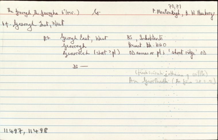
Gearagh East
(English)
Hierarchy
county
barony
civil parish
Centrepoint
51.8867, -8.98039latitude, longitude
Irish Grid (with letter)
Computing...
Irish Grid (without letter)
Computing...
Irish Transverse Mercator (ITM)
Computing...
Archival records
Historical references
| 1827 |
Gerah Wood
|
TAB Leathanach: 10
|
| 1841 |
Geragh East, -West
|
|
| 1841 |
Geragh
|
|
| 1841 |
gearrach (le dúch anuas ar pl(OC)), short ridge
|
|
| 1841 |
Gearragh
|
|
| 1898 |
It [the River Toon] flows for a considerable distance through low lands before entering the latter [The Lee] east of Toon's bridge. In wet weather, when the Lee becomes flooded, inundating the islands of the Gaortha, it holds back the water of the Toon,
|
JCHAS Leathanach: 4.11(1898)
|
Please note: Some of the documentation from the archives of the Placenames Branch is available here. It indicates the range of research contributions undertaken by the Branch on this placename over the years. It may not constitute a complete record, and evidence may not be sequenced on the basis of validity. It is on this basis that this material is made available to the public.
Archival and research material provided on this site may be used, subject to acknowledgement. Issues regarding republication or other permissions or copyright should be addressed to logainm@dcu.ie.