Hierarchy
county
barony
municipal district
civil parish
electoral division
townland
subunits
townland
Ardmalin
(English)
Hierarchy
county
barony
municipal district
civil parish
electoral division
Centrepoint
55.3699, -7.36649latitude, longitude
Irish Grid (with letter)
Computing...
Irish Grid (without letter)
Computing...
Irish Transverse Mercator (ITM)
Computing...
Archival records
Historical references
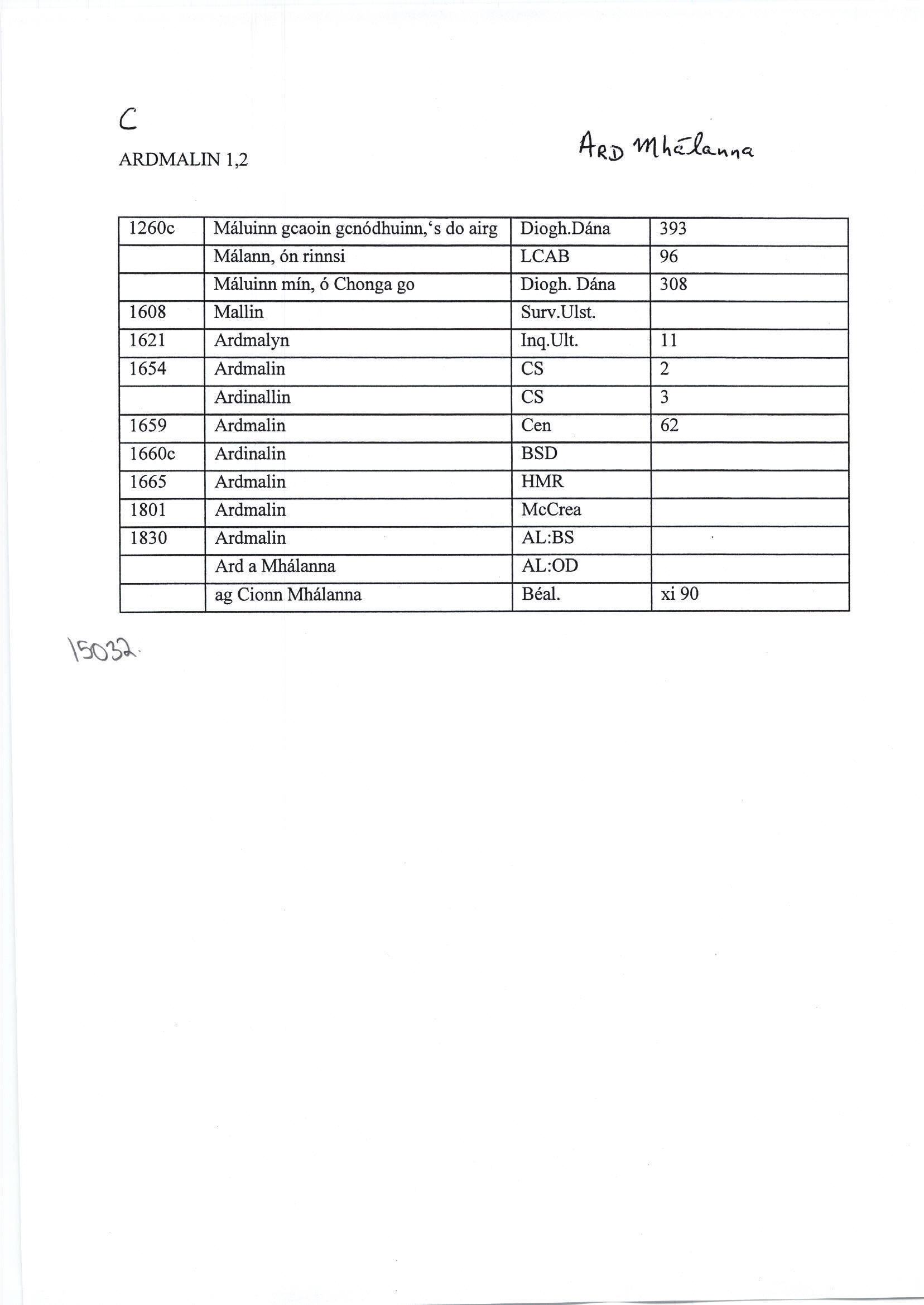
| 1260c |
Máluinn gcaoin gcnódhuinn,‘s do airg
|
Dioghl. D Leathanach: 393
|
| 1260c |
Máluinn mín, ó Chonga go
|
Dioghl. D Leathanach: 308
|
| 1608 |
Mallin
|
|
| 1621 |
Ardmalyn
|
Inq. Ult. Leathanach: 11
|
| 1625 |
Ardmalyne
|
Inq. Ult. 1 CI
|
| 1654 |
Ardinallin
|
CS III Leathanach: 3
|
| 1654 |
Ardmalin
|
CS III Leathanach: 2
|
| 1659 |
Ardmalin
|
Cen. Leathanach: 62
|
| 1660c |
Ardinalin
|
|
| 1661 |
Ardmalin
|
|
| 1665 |
Ardmalin
|
|
| 1669 |
Ardmalyne alias Ardmanlyne
|
Chic. Pat. 136
|
| 1707 |
Ardmullin
|
CGn. 19.31.9602
|
| 1718 |
Ardmalin
|
CGn. 21.292.11549
|
| 1767-1770 |
Ardmalin
|
Crow Inishowen D835/1/1/34
|
| 1801 |
Ardmalin
|
|
| 1828 |
Ardmalin
|
|
| 1828 |
Quarterland of Ardmalin
|
|
| 1830 |
Ardmalin
|
|
| 1830 |
Ard a Mhálanna
|
|
| 1835 |
Ardmalyne
|
|
| 1835 |
Ardmalin
|
|
| 1835 |
The Height of Malin
|
|
| 1835 |
High Malin
|
|
| 1835 |
High Malin
|
|
| 1835 |
Ard, high & Malin
|
|
| 1835 |
Ard, height & Malle declivity
|
|
| 1835 |
Ard high, High Malin
|
|
| 1835 |
Ard an Height "maoil in i. mall brow of a hill or Maelan may import St. Maclanns or Maelona's
|
Chichester, Revd. E.:AL (DG) Statistical Report
|
| 1835 |
Ard Maolainn, beacon hill
|
|
| 1931 |
Málann, ón rinnsi
|
LCAB Leathanach: 96
|
| 1941 |
ag Cionn Mhálanna
|
Béal. Leathanach: XI 90
|
Please note: Some of the documentation from the archives of the Placenames Branch is available here. It indicates the range of research contributions undertaken by the Branch on this placename over the years. It may not constitute a complete record, and evidence may not be sequenced on the basis of validity. It is on this basis that this material is made available to the public.
Archival and research material provided on this site may be used, subject to acknowledgement. Issues regarding republication or other permissions or copyright should be addressed to logainm@dcu.ie.
Permanent link
https://www.logainm.ie/15032.aspxFolklore
The National Folklore Collection (dúchas.ie) contains material related to this place: