Hierarchy
county
barony
civil parish
townland, island or archipelago
townland, island or archipelago
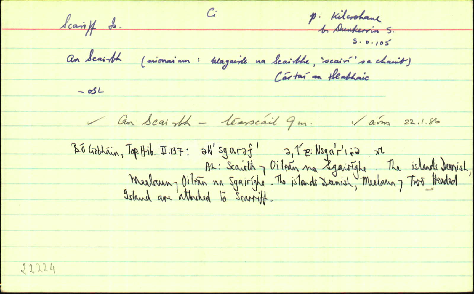
Scariff
(English)
Hierarchy
county
barony
civil parish
Centrepoint
51.7303, -10.2513latitude, longitude
Irish Grid (with letter)
Computing...
Irish Grid (without letter)
Computing...
Irish Transverse Mercator (ITM)
Computing...
Archival records
Historical references
| 1571 |
Skaryffe
|
F Leathanach: 1687
|
| 1571 |
Skryffe
|
|
| 1577 |
Skariff
|
F Leathanach: 3161
|
| 1756 |
Scariff
|
Smith Hist. Kerry, map Leathanach: 94
|
| 1756 |
Scariff Isl.
|
|
| 1776 |
Scarav I.
|
Mackenzie Leathanach: VIII/81
|
| 1800c |
ó'n Scairbh
|
Diar. na Bolg. Leathanach: 53
|
| 1800c. |
An Scairbh
|
Tomás Ruadh Leathanach: 108
|
| 1826 |
Scarriff Island
|
TAB Nóta: (Kilcrohane)
|
| 1841 |
Scarriff
|
BS:AL Leathanach: Ci066,32
|
| 1841 |
Scariff
|
Smith Hist. Kerry:AL Leathanach: Ci066,32
|
| 1841 |
Scairbh, 'and,' oileán na sgairíghe, 'island of the shallow ford'
|
OD:AL Leathanach: Ci066,32
|
| 1841 |
Scairbh / Scairbhe / Scarree
|
pl:AL Leathanach: Ci066,32
|
| 1841 |
Scariff
|
OD (corr.):AL Leathanach: Ci066,32
|
| 1841 |
About a league to the South West of this island which is at low water joined to the shore, there are two islands called Scariff and Dinish; the former is an high mountain in the sea and hath one family on it, who take care of some cows and make a considerable quantity of butter; on the top of the highest ground in the island is a ruined hermitage. These islands with the continent are farmed from the Earl of Cork and Orrery by Mr. Daniel Connell (Hist. Kerry, p.p. 93 and 94) [An cur síos seo in Smith, lch. 94]
|
LSO (Ci) Leathanach: 75/155-6
|
| 1927c |
An Sgairibh
|
LSh. Í Chonaill Leathanach: 255
|
| 1945 |
na Scairbhe(gin.)
|
Béal. Leathanach: XV 12
|
| 1945 |
Oileáin Scairbhe(gin.)
|
Béal. Leathanach: XV 30
|
| 1948 |
An Sgairbh
|
LSh. Í Chonaill (réamhrá) Leathanach: ix
|
| 1955 |
An Scairbh
|
|
| 1970c. |
Top. Hib. Leathanach: II 137
|
|
| 1970c. |
Top. Hib. Leathanach: II 138
|
|
| 1970c. |
Top. Hib. Leathanach: II 139
|
|
| 1970c. |
Top. Hib. Leathanach: II 140
|
|
| 1984 |
An Scairbh
|
Top. Hib. Leathanach: 137, Imleabhar: II
|
| 1984 |
əNˈsgɑrəf′
Áit.
|
Top. Hib. Imleabhar: II, Leathanach: 137
|
| 1984 |
(əN)ˈsgɐr′iv′
Áit.
|
Top. Hib. Imleabhar: II, Leathanach: 137
|
| 1984 |
əˌl′ɐ:Nsgɑˈr′iˑə
Áit.
|
Top. Hib. Imleabhar: II, Leathanach: 137
|
| 1984 |
ˌl′ɐ:Nəˈsgɐr′if′ə
Áit.
|
Top. Hib. Imleabhar: II, Leathanach: 137
|
| 1984 |
iˈl′a:Nəˈsgɐr′if′(ə)
Áit.
|
Top. Hib. Imleabhar: II, Leathanach: 137
|
| 1984 |
ˈsgarəf′
Áit.
|
Top. Hib. Imleabhar: II, Leathanach: 137
|
| 1984 |
-Nəˌsgɐˈr′iˑə
Áit.
|
Top. Hib. Imleabhar: II, Leathanach: 137
|
| 1984 |
[-]sgɑˈr′i:
Áit.
|
Top. Hib. Imleabhar: II, Leathanach: 137
|
| 1984 |
Nˈsgɐr′əv′
Áit.
|
Top. Hib. Imleabhar: II, Leathanach: 137
|
| 1984 |
əˈsgɐr′əv′
Áit.
|
Top. Hib. Imleabhar: II, Leathanach: 137
|
| 1984 |
eˈsgɐr′if′
Áit.
|
Top. Hib. Imleabhar: II, Leathanach: 137
|
| 1984 |
əNˈsgɑr′ə
Áit.
|
Top. Hib. Imleabhar: II, Leathanach: 137
|
| 1984 |
ˈsgɐr′əv′
Áit.
|
Top. Hib. Imleabhar: II, Leathanach: 137
|
| 1986 |
An Scairbh
|
Please note: Some of the documentation from the archives of the Placenames Branch is available here. It indicates the range of research contributions undertaken by the Branch on this placename over the years. It may not constitute a complete record, and evidence may not be sequenced on the basis of validity. It is on this basis that this material is made available to the public.
Archival and research material provided on this site may be used, subject to acknowledgement. Issues regarding republication or other permissions or copyright should be addressed to logainm@dcu.ie.