Hierarchy
county
barony
civil parish
townland
civil parishtownland
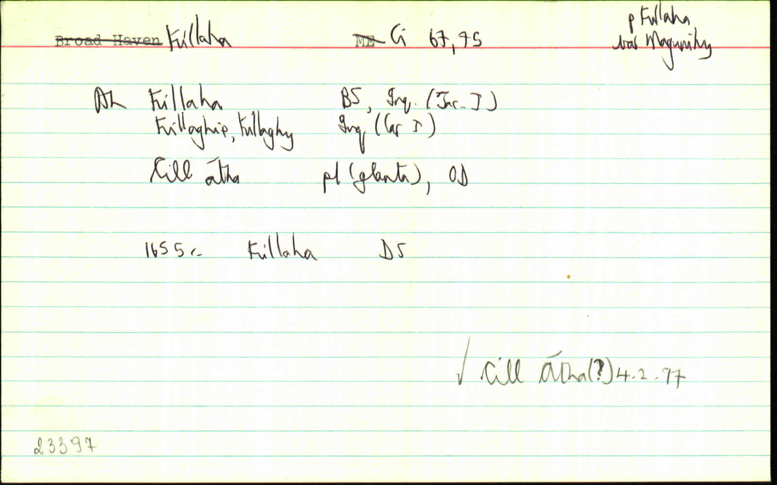
Killaha
(English)
Centrepoint
52.0227, -9.39259latitude, longitude
Irish Grid (with letter)
Computing...
Irish Grid (without letter)
Computing...
Irish Transverse Mercator (ITM)
Computing...
Archival records
Historical references
| n/a |
Cárta: Cill Átha 1997
|
|
| n/a |
An Seabhac: Cill Átha. Cuid d’fhothrach na seanchille agus an reilig ann. Is ann a bhí comhnaidhe agus Caisleán Ui Dhonnchadha. Tá fothrach an tsean-chaislean fós ann. Roinnt daoine a deir nach áth abhann atá sa dara cuid den ainm ach ainm an Naoimh Ághtha (Agatha) .i. Cill Ághtha. Tá teampall an phar. ainmnithe – “St. Agatha’s Church”.
|
|
| 1598 |
Killa
Foirgneamh gan díon léirithe anseo
|
Clancarthy Surv. Leathanach: Lsc. (Magonny)
|
| 1613 |
Killaha
|
CPR Leathanach: 243b
|
| 1614 |
Killaha
|
CPR Leathanach: 268b
|
| 1629 |
Killaghie
|
Inq.(Ci) Leathanach: 226, Imleabhar: I
|
| 1630 |
Killaghy
|
Inq.(Ci) Leathanach: 229, Imleabhar: I
|
| 1655c. |
Killaha
|
|
| 1659 |
Killahy
|
Cen. Leathanach: 255
|
| 1660 |
Killaha
|
BSD Leathanach: 53:01
|
| 1670 |
Kilaha
|
ASE Leathanach: 224:05
|
| 1738 |
Killaha
|
CGn. Leathanach: 214.63853, Imleabhar: 90
|
| 1753 |
Killahy
|
CGn. Leathanach: 236.110373, Imleabhar: 164
|
| 1756 |
Killagha parish
|
Smith Hist. Kerry Imleabhar: 120
|
| 1824 |
Killaha
|
TAB Leathanach: 27
|
| 1841 |
Killaha
|
Inq. J I:AL Leathanach: Ci082,40
|
| 1841 |
Killaghin
|
Inq. C I:AL Leathanach: Ci082,40
|
| 1841 |
Killaghy
|
Inq. C I:AL Leathanach: Ci082,40
|
| 1841 |
Killaha
|
Vallancey Map:AL Leathanach: Ci082,40
|
| 1841 |
[Killaha]
"See parish." [Nóta OD]
|
OD:AL Leathanach: Ci082,40
|
| 1841 |
[Killaha]
"O'Donohoe's Castle is also in the E. end of this townland."
|
Desc. Rem.:AL Leathanach: Ci082,40
|
| 1841 |
Killaha
|
BS:AL Leathanach: Ci082,40
|
| 1841 |
Killaha
|
BM:AL Leathanach: Ci082,40
|
| 1841 |
Killaha
|
Larkin (Ci):AL Leathanach: Ci082,40
|
| 1841 |
Killaha
|
Acts of Settlement:AL (Ci) Leathanach: Ci082,40
|
| 1841 |
Cill Atha, 'cell or church of the ford'
Is pronounced by the natives when speaking Irish as if written Cill Atha, which means in English Cell or Church of the Ford. … this church stands in a large graveyard now much in use as a cemetery. ... About half a furlong to the South of this old church on a rising ground, at the North side of the mountain of Crochan-Glen-Flesk, stands O’Donohoe’s Castle of Killaha. The fifth day of February was formerly kept holy in this Parish in honour of the Patron Saint whose name is now forgotton.
|
LSO (Ci) Leathanach: 90-93 / 186-89. OD, AC
|
| 1841 |
Cill átha
|
pl:AL Leathanach: Ci082,1
|
| 1841 |
Cill átha, 'church of the ford'
|
OD:AL Leathanach: Ci082,1
|
| 1841 |
Killagha
|
Smith Hist. Kerry:AL Leathanach: Ci082,1
|
| 1841 |
Killaha
|
OD:AL Leathanach: Ci082,1
|
| 1841 |
Killaha
|
Vallancey Map:AL Leathanach: Ci082,1
|
| 1841 |
Killaha (Ph of)
|
Acts of Settlement:AL (Ci) Leathanach: Ci082,1
|
| 1841 |
Killaha (Ph of)
|
BS:AL Leathanach: Ci082,1
|
| 2017 |
ˌkiˈlahə
|
Áit. Uimhir : 170717, Cainteoir: 011
|
| 2017 |
ˌkiˈlahə
|
Áit. Uimhir : 170718, Cainteoir: 015
|
| 2017 |
ˌkiˈlahə
|
Áit. Uimhir : 170718, Cainteoir: 017
|
Please note: Some of the documentation from the archives of the Placenames Branch is available here. It indicates the range of research contributions undertaken by the Branch on this placename over the years. It may not constitute a complete record, and evidence may not be sequenced on the basis of validity. It is on this basis that this material is made available to the public.
Archival and research material provided on this site may be used, subject to acknowledgement. Issues regarding republication or other permissions or copyright should be addressed to logainm@dcu.ie.
Permanent link
https://www.logainm.ie/23397.aspxOpen data
Application programming interface (API)
Available under
Creative Commons Attribution 4.0 International (CC BY 4.0)
API key required to access data
Linked Logainm
Formats: RDF | RDF N3 | RDF JSON | RDF XML
Operated by Digital Repository of Ireland