Hierarchy
county
barony
civil parish
townland
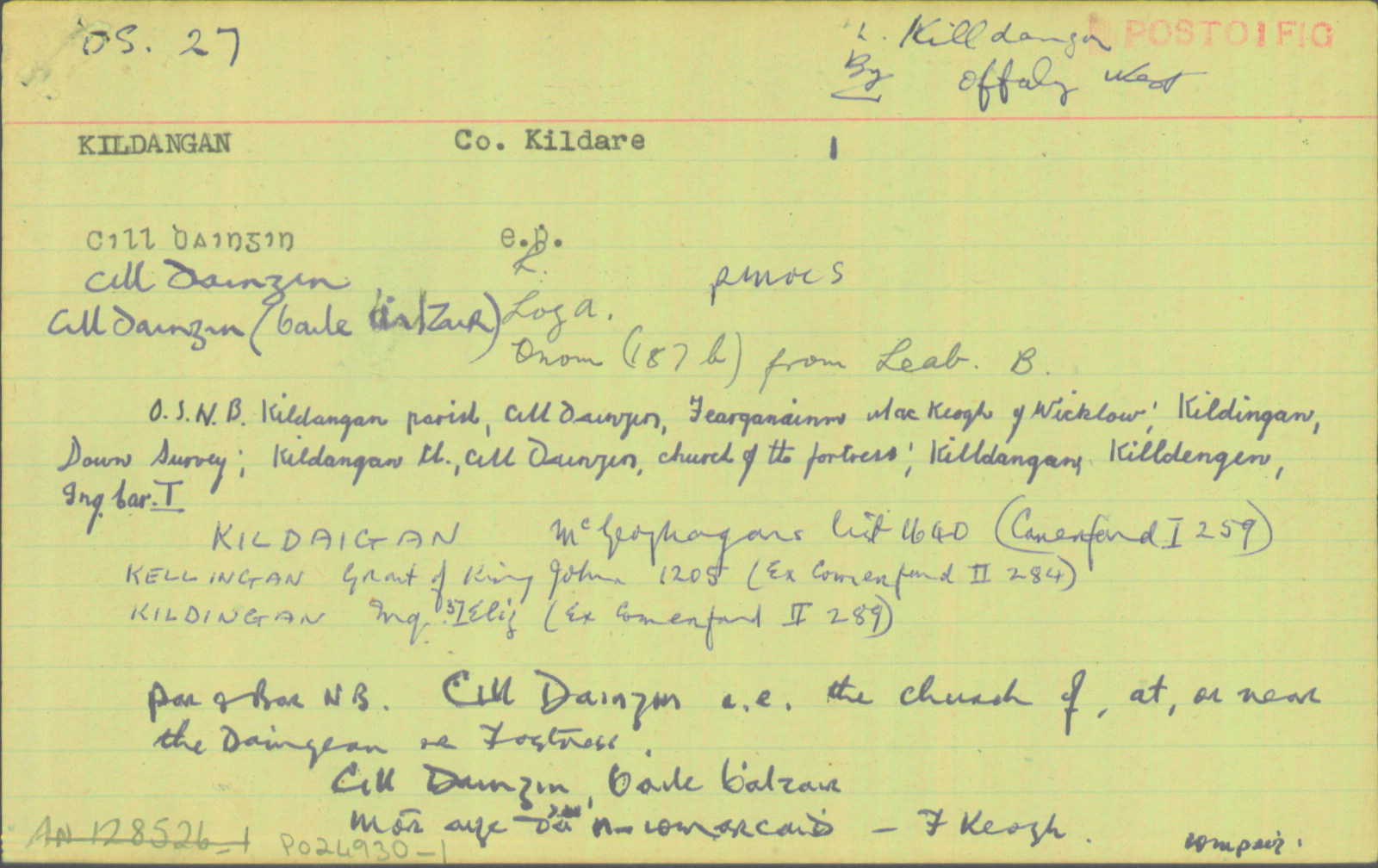
Cill Daingin
genitive: Chill Daingin
(Irish)
Kildangan
(English)
Hierarchy
county
barony
civil parish
Centrepoint
53.1055, -6.99152latitude, longitude
Irish Grid (with letter)
Computing...
Irish Grid (without letter)
Computing...
Irish Transverse Mercator (ITM)
Computing...
Archival records
Historical references
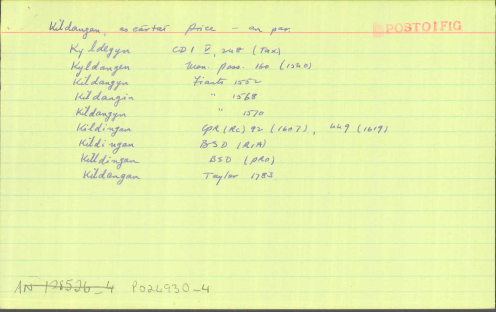
| 1540 |
Kyldangen [Par.]
|
Ir. Mon. Poss. Leathanach: 160
|
| 1552 |
Kildangyn [Par.]
|
F Leathanach: 1131 Ed.
|
| 1560c |
Cill Daingin
|
LBran. Leathanach: 65.1697
|
| 1568 |
Kildangin, [rectory and tithes of]
|
F Leathanach: 1216
|
| 1570 |
Kildangyn
|
F Leathanach: 1575
|
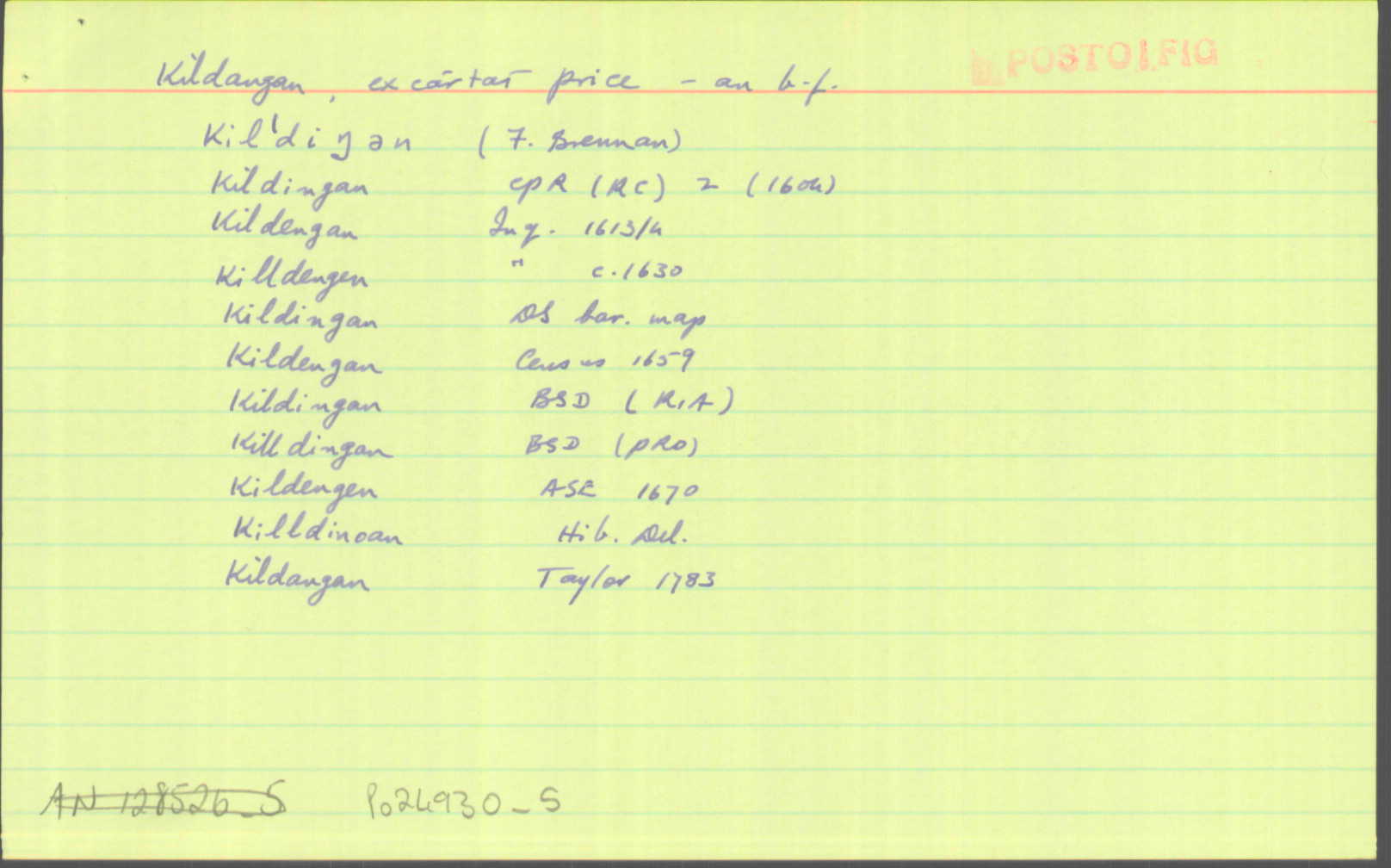
| 1604 |
Kildingan
|
CPR Leathanach: 2
|
| 1606 |
Kildingan
|
CPR Leathanach: 92
|
| 1607 |
Kildingan [Par.]
|
CPR Leathanach: 139
|
| 1613 |
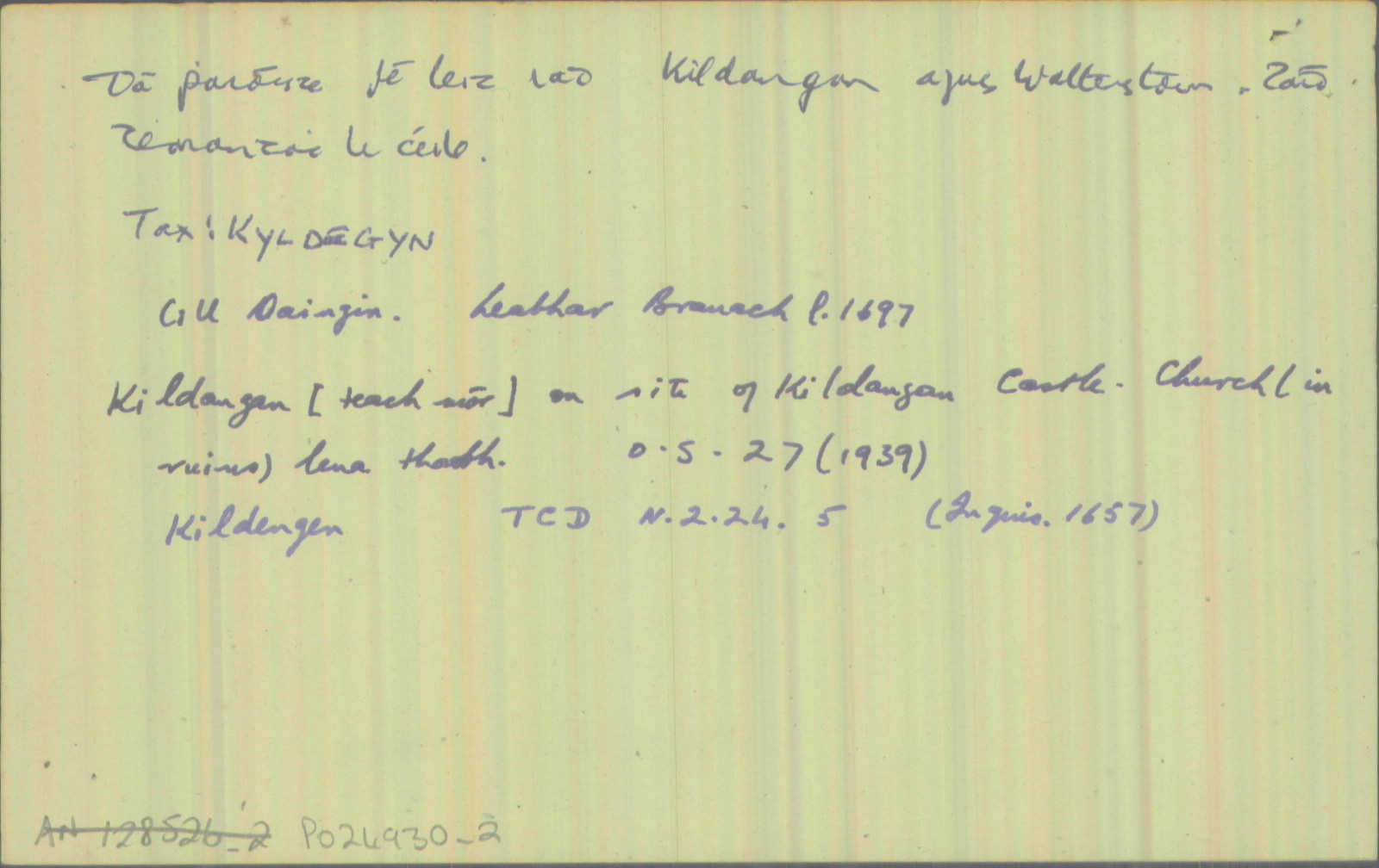
Kildengan
|
Inq. Lag. Leathanach: 14 J I
|
| 1619 |
Kildingan [Par.]
|
CPR Leathanach: 445
|
| 1619 |
Kildingan [Par.]
|
CPR Leathanach: 447
|
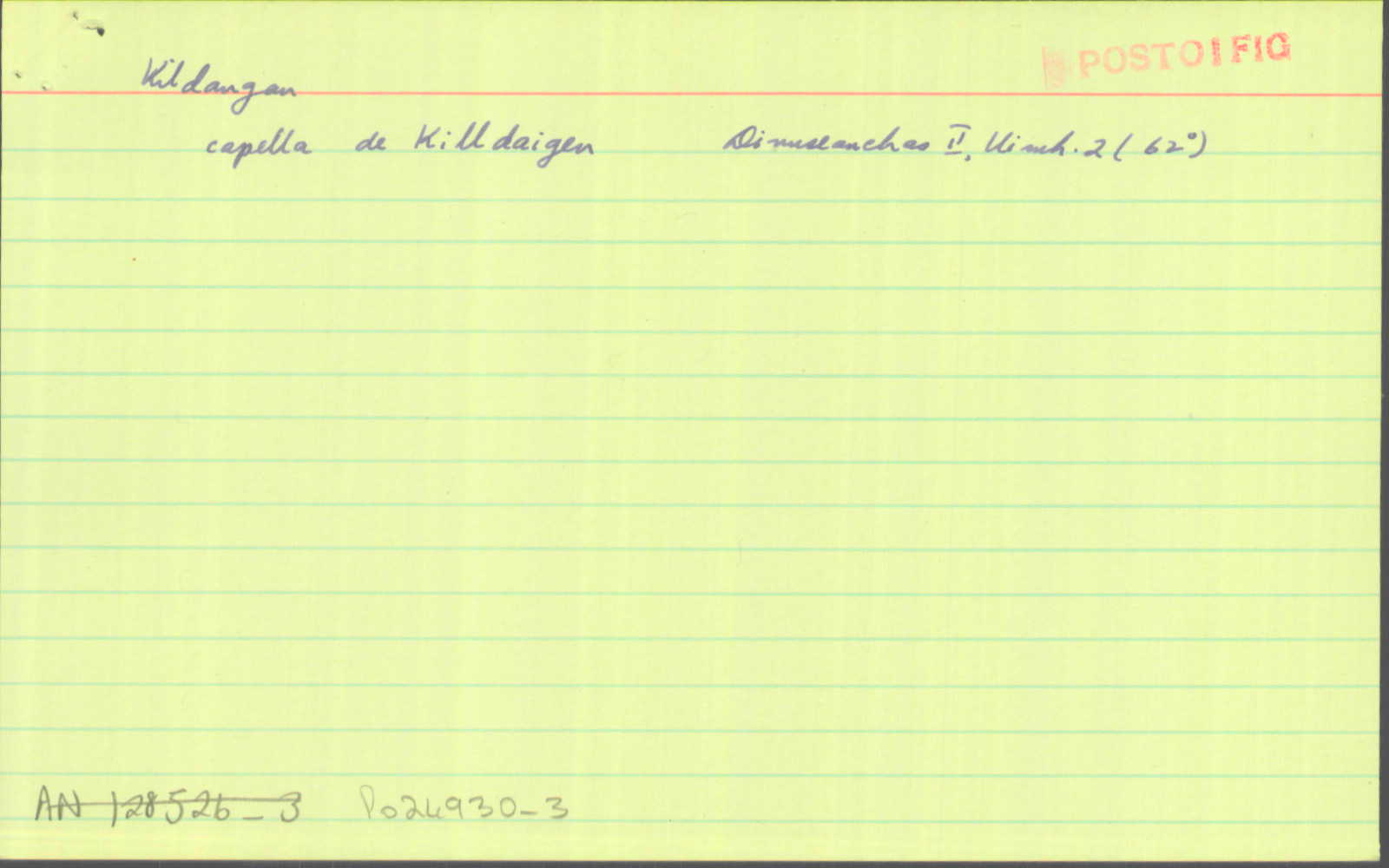
| 1629-44 |
capella de Killdaigen
|
Cillsheanchas Chill Dara Leathanach: 2.31
|
| 1630c. |
Killdangan
|
Inq. Lag. Leathanach: 90 C I
|
| 1630c. |
Killdengen
|
Inq. Lag. Leathanach: 90 C I
|
| 1655 |
Kildingan
|
|
| 1659 |
Kildengan
|
Cen. Leathanach: 395
|
| 1660c |
Killcullen & part Tully par.
|
BSD (CD) Leathanach: 50
|
| 1660c |
Killdingan P.
|
BSD (CD) Leathanach: 50
|
| 1660c |
Stracumny
|
BSD (RIA) Leathanach: 50
|
| 1660c |
Strahard, Ballivarney
|
BSD (RIA) Leathanach: 50
|
| 1660c |
Kildingan
|
|
| 1660c |
Kildingan P.
|
|
| 1670 |
Kildengen
|
ASE Leathanach: 221
|
| 1670 |
Shrahard
|
ASE Leathanach: 221
|
| 1685 |
Killdinoan
|
|
| 1685 |
Shruhard
|
|
| 1727-1838 |
Kildangan
|
Longfield: Baronies (CD) 21 F. 35 Leathanach: 21F35(51)
|
| 1752 |
Killdangan
|
|
| 1783 |
Ca. Rs. Kildangan
|
|
| 1783 |
Kildangan P.
|
|
| 1787-1839 |
Kildangan Demesne
|
Off. West Maps Leathanach: 21F36 (85)
|
| 1807 |
Kildangan
|
Stat. Surv. (CD) Leathanach: xliii
|
| 1837 |
Kildangan
|
BS:AL Leathanach: 1,3
|
| 1837 |
Kildangan
|
Taylor Co. Map 1783:AL Leathanach: 1,3
|
| 1837 |
Kildangan
|
Stat. Survey (CD):AL Leathanach: 1,3
|
| 1837 |
Kildangan
[Harvey]
|
Cassidy, H.:AL Leathanach: 1,3
|
| 1837 |
Killdangan; Killdengen
|
Inq. C I:AL Leathanach: 1,3
|
| 1837 |
Cill daingin, 'church of the fortress'
|
OD:AL Leathanach: 1,3
|
| 1837 |
Kildangan
|
OD:AL Leathanach: 1,3
|
| 1837 |
[Kildangan]
"…a pond called Thubbertige…"
|
Desc. Rem.:AL Leathanach: 1,3
|
| 1837 |
the Church of Kildangan having become delapidated
|
Top. Dict. Imleabhar: II, Leathanach: 674
|
| 2009-2010 |
kilˈdaŋin
|
Please note: Some of the documentation from the archives of the Placenames Branch is available here. It indicates the range of research contributions undertaken by the Branch on this placename over the years. It may not constitute a complete record, and evidence may not be sequenced on the basis of validity. It is on this basis that this material is made available to the public.
Archival and research material provided on this site may be used, subject to acknowledgement. Issues regarding republication or other permissions or copyright should be addressed to logainm@dcu.ie.
Permanent link
https://www.logainm.ie/24930.aspxFurther information about this place
Open data
Application programming interface (API)
Available under
Creative Commons Attribution 4.0 International (CC BY 4.0)
API key required to access data
Linked Logainm
Formats: RDF | RDF N3 | RDF JSON | RDF XML
Operated by Digital Repository of Ireland