Hierarchy
county
barony
municipal district
civil parish
electoral division
townland
townland
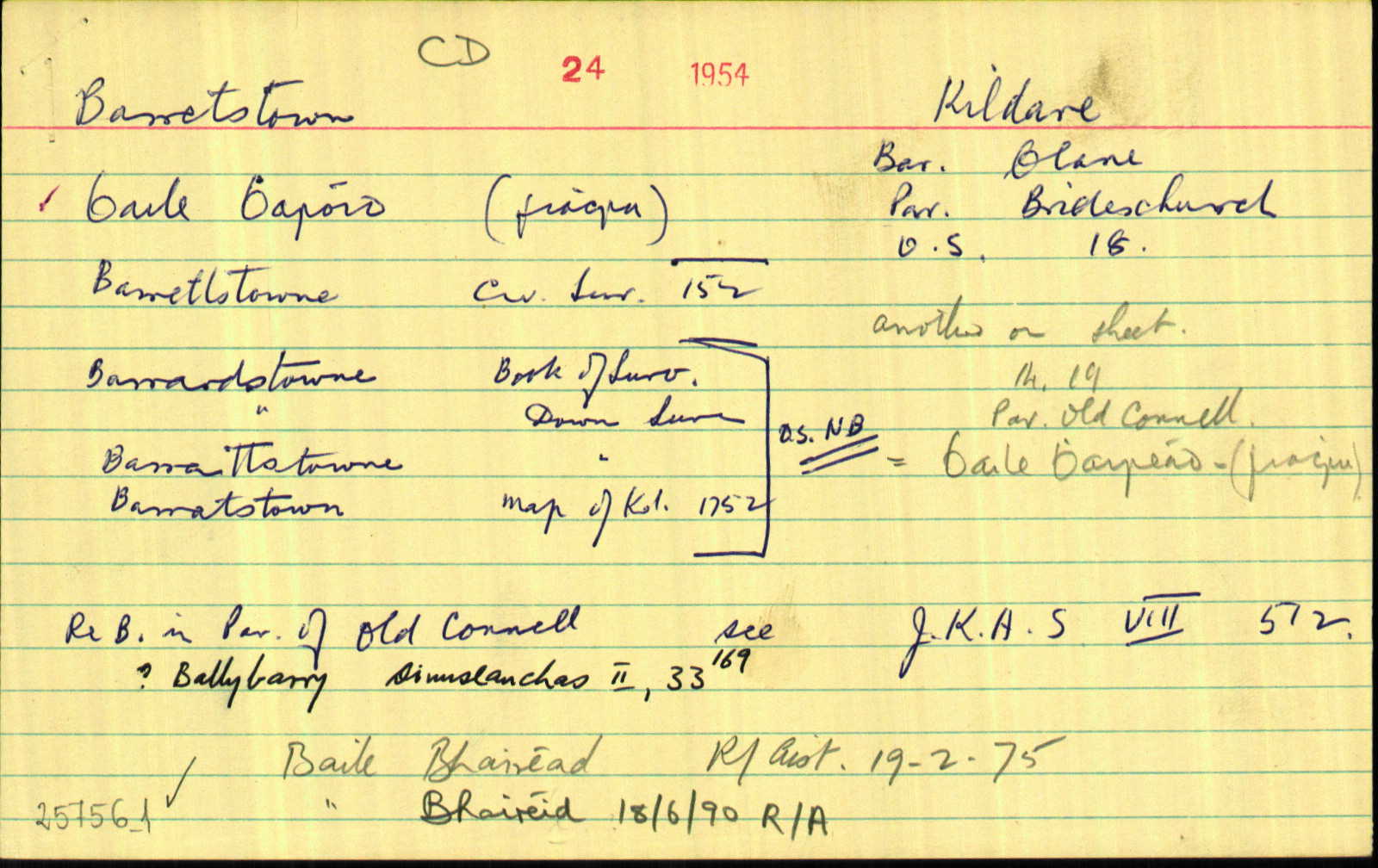
Barrettstown
(English)
Hierarchy
county
barony
municipal district
civil parish
electoral division
Centrepoint
53.2583, -6.69339latitude, longitude
Irish Grid (with letter)
Computing...
Irish Grid (without letter)
Computing...
Irish Transverse Mercator (ITM)
Computing...
Archival records
Historical references
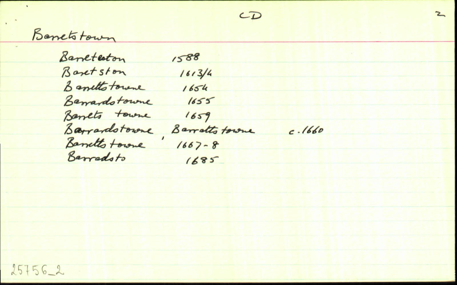
| 1588 |
Barreteston
|
F Leathanach: 5217
|
| 1613 |
Baretston
|
Inq. Lag. Leathanach: 13 J I
|
| 1654 |
Barrettstowne
|
CS VIII Leathanach: 152154.155
|
| 1655 |
Barradstowne
|
|
| 1659 |
Barrets towne
|
Cen. Leathanach: 399
|
| 1660c |
Barradstowne
|
BSD (CD) Leathanach: 31
|
| 1660c |
Barrattstowne
|
BSD (CD) Leathanach: 31
|
| 1660c |
Barrattstowne
|
BSD (CD) Leathanach: 31
|
| 1660c |
Barrenrath
|
BSD (CD) Leathanach: 31
|
| 1668 |
Barrettstowne
|
ASE Leathanach: 173
|
| 1685 |
Barradsto
|
|
| 1705 |
Barrettstowne
|
Neville Est. Maps Leathanach: 14A30 (2)
|
| 1732 |
Barrettstown, Waterville ows. Waterstown ows.
|
CGn. Leathanach: 70.326.43553
|
| 1752 |
Barratstown
|
|
| 1783 |
Barretstown
|
|
| 1807 |
Barretstown
|
Stat. Surv. (CD) Leathanach: 204
|
| 1837 |
Barretstown
|
BS:AL Leathanach: 1,8
|
| 1837 |
Barratstown
|
Map of Kildare 1752:AL Leathanach: 1,8
|
| 1837 |
Barratts town
|
Bk. Lands, Index to:AL Leathanach: 1,8
|
| 1837 |
Barretts town
[1780]
|
Bk. Lands, Index to:AL Leathanach: 1,8
|
| 1837 |
Barrardstowne
|
BSD:AL Leathanach: 1,8
|
| 1837 |
Barrardstowne
|
Petty Eng. Map 1682:AL Leathanach: 1,8
|
| 1837 |
Barretstown
|
Bar. Cons.:AL Leathanach: 1,8
|
| 1837 |
Barrardstowne
|
DS:AL Leathanach: 1,8
|
| 1837 |
Gleabland in Barrattstowne
|
DS:AL Leathanach: 1,8
|
| 1837 |
Barretstowne
|
Inq. J I:AL Leathanach: 1,8
|
| 1837 |
Barretstown
|
Local (OK):AL Leathanach: 1,8
|
| 1837 |
Barrettstown
|
OD:AL Leathanach: 1,8
|
| 1837 |
[Barrettstown]
"Digleys Bridge is in the North of townland."
|
Desc. Rem.:AL Leathanach: 1,8
|
| 2009-2010 |
ˈbaritstoun
|
Please note: Some of the documentation from the archives of the Placenames Branch is available here. It indicates the range of research contributions undertaken by the Branch on this placename over the years. It may not constitute a complete record, and evidence may not be sequenced on the basis of validity. It is on this basis that this material is made available to the public.
Archival and research material provided on this site may be used, subject to acknowledgement. Issues regarding republication or other permissions or copyright should be addressed to logainm@dcu.ie.