Hierarchy
county
barony
civil parish
townland
townland
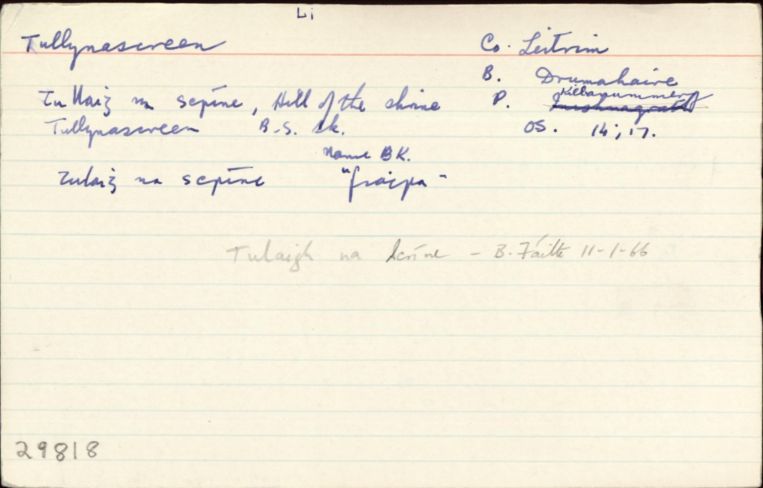
Tullynascreen
(English)
Hierarchy
county
barony
civil parish
Centrepoint
54.1788, -8.28359latitude, longitude
Irish Grid (with letter)
Computing...
Irish Grid (without letter)
Computing...
Irish Transverse Mercator (ITM)
Computing...
Archival records
Historical references
|
1979 Tulaigh na Scríne NÓM
|
||
|
Cuardaíodh na foinsí seo ach níor aimsíodh rud ar bith: DS, Hib.Del., Cen., ASE, BSD, Inq., CPR, Fi.Eliz., Larkin
|
||
| n/a |
"Pinkman: Tulaigh-na-Scríne = Hill of the shrine. Scrín, a shrine, an ornamental case, in which the relics of a saint were enclosed. See Skreeny. "
|
|
|
"Arch Inventory: Earthwork (site). On a grass- and rush-covered plateau (169). Mass-rock. On the N bank of an E-W stream. A boulder with no markings where Mass was said during the Penal period (199) "
|
||
| n/a |
"Comhfhreagras (Úd.Stáit, Iúil 2002): Tulaigh na Scríne cf. Skreeny, gin "
|
|
| n/a |
"LSO: “On one of the Doonbran Islands [féach liosta breise: Dunbrandon srl.], which are on the Bónet River at the junction of the Parishes of Drumlease, Killanumery in Co. of Leitrim and of Killery in Co. of Sligo, is an old Castle in ruins, which the people say was built by a man named Harrison; hence it is called Harrison’s Castle; the walls of it are about fifteen feet in height. Braid-Shliabh mentioned in the Annals of the Four Masters at the year 1586, is now called Braidh-Shliabh and should be anglicised Bralieve. It lies four miles south of the Town of Dromahaire, on the boundary of the Counties of Leitrim and Sligo. Some say it is five and others that it is seven miles long. The direction of its bridge is nearly northwest. It is called Braulieve on Larkin’s Map.” ” 133/263 "
|
|
| 1835 |
Tullinaskreena
|
TAB Leathanach: Innéacs 37 (60:16/6)
|
| 1835 |
Tullynascreeny
Léarscáil: Fox
|
TAB Leathanach: (60:16/6)
|
| 1836 |
Tullynascreen
|
|
| 1836 |
Tullaigh na scríne
|
|
| 1836 |
Tulaigh na scrín:e
'hill of the shrine'
|
|
| 1836 |
Tullynascreen
|
Please note: Some of the documentation from the archives of the Placenames Branch is available here. It indicates the range of research contributions undertaken by the Branch on this placename over the years. It may not constitute a complete record, and evidence may not be sequenced on the basis of validity. It is on this basis that this material is made available to the public.
Archival and research material provided on this site may be used, subject to acknowledgement. Issues regarding republication or other permissions or copyright should be addressed to logainm@dcu.ie.
Permanent link
https://www.logainm.ie/29818.aspxFurther information about this place
Folklore
The National Folklore Collection (dúchas.ie) contains material related to this place: