Hierarchy
county
barony
civil parish
townland
townland
Dergvone
(English)
Hierarchy
county
barony
civil parish
Centrepoint
54.2315, -8.06708latitude, longitude
Irish Grid (with letter)
Computing...
Irish Grid (without letter)
Computing...
Irish Transverse Mercator (ITM)
Computing...
Archival records
Historical references
| n/a |
"Pinkman: Dearg-mhóin = Red bog. Dergvone is in the mountain district of Killarga Parish, and lies on the CO. Cavan border. "
|
|
|
"Arch. Inventory: Cashel. At the crest of the E-facing slope of a ridge in the Owennayle river valley (78). Sweathouse (site). At the S edge of a W-E ravine and stream (220). "
|
||
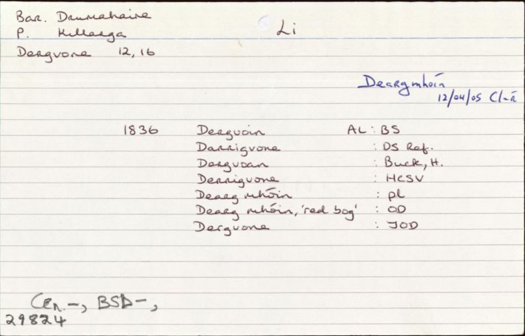
| 1660c |
Daingnone[lit?]
|
BSD Leathanach: 61
|
| 1668 |
Derrigvoan
|
ASE Leathanach: 161:34
|
| 1685 |
Darigron
|
|
| 1738 |
Dergvona
|
CGn. Imleabhar: 90.282.64314
|
| 1835 |
Dergvoin
|
TAB Leathanach: 22, 24, 60 (60:16/7)
|
| 1836 |
Dergvoin
|
|
| 1836 |
Darrigvone
|
|
| 1836 |
Dergvoan
|
|
| 1836 |
Derrigvone
|
|
| 1836 |
Dearg mhóin:
|
|
| 1836 |
Dearg mhóin:,
'red bog'
|
|
| 1836 |
Dergvone
|
|
| 2005 |
Deargmhóin
Le haghaidh CLÁR
|
Please note: Some of the documentation from the archives of the Placenames Branch is available here. It indicates the range of research contributions undertaken by the Branch on this placename over the years. It may not constitute a complete record, and evidence may not be sequenced on the basis of validity. It is on this basis that this material is made available to the public.
Archival and research material provided on this site may be used, subject to acknowledgement. Issues regarding republication or other permissions or copyright should be addressed to logainm@dcu.ie.
Permanent link
https://www.logainm.ie/29824.aspxFurther information about this place
Folklore
The National Folklore Collection (dúchas.ie) contains material related to this place: