Hierarchy
county
barony
municipal district
civil parish
electoral division
townland
subunits
townland
Cappaghduff East
(English)
Hierarchy
county
barony
municipal district
civil parish
electoral division
Centrepoint
53.6486, -9.37206latitude, longitude
Irish Grid (with letter)
Computing...
Irish Grid (without letter)
Computing...
Irish Transverse Mercator (ITM)
Computing...
Properties
GGaeltacht
Archival records
Historical references
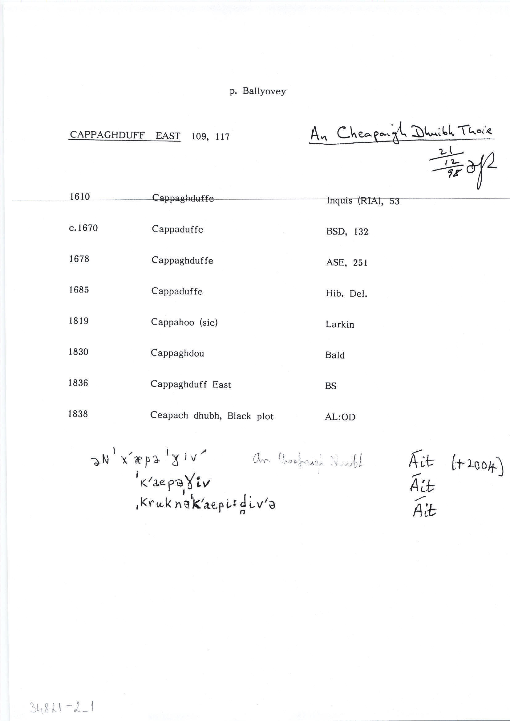
| 1610 |
(?)Keppaghduffe
|
CPR Leathanach: 157
|
| 1610 |
Cappaghduffe in mountaynes of Partry
|
Inq.(ME) Leathanach: I.53
|
| 1611 |
Cappaghduffe
|
CPR Leathanach: 213
|
| 1615 |
Cappaghduff ½ qr
|
CPR Leathanach: 288
|
| 1661 |
Cappaduffe Mount. of Ballynasse
|
BSD (ME) Leathanach: 132
|
| 1666 |
Capaghduffe
|
L. Blosse Papers Leathanach: 175 §55
|
| 1678 |
Cappaghduffe
|
ASE Leathanach: 251
|
| 1684 |
Cappaghduffe
|
L. Blosse Papers Leathanach: 178 §60
|
| 1685 |
Cappaduffe, Gappagoffe
|
Hib. Del. Nóta: (ME)
|
| 1700 |
Cappaghduffe, Gortvallderig and
|
L. Blosse Papers Leathanach: 180 §62
|
| 1710c |
Cappoghduffe
|
CRL Leathanach: 2A.3.16, 61
|
| 1778c |
Capaghduffe
|
CGn. Imleabhar: 371.570.250887
|
| 1787 |
Cappaghduff
|
QRL Leathanach: 2A.6.69, 72
|
| 1830 |
Cappaghdue
|
Bald Leathanach: 18
|
| 1830 |
Cappaduffe
|
|
| 1830 |
Cappaghduff North [sic]
|
TAB Leathanach: §34
|
| 1838 |
Cappaghduffe
|
Excise QRL:AL Leathanach: ME030,9
|
| 1838 |
Cappaduffe
|
Co. Bk.:AL Leathanach: ME030,9
|
| 1838 |
Cappagduff
|
GJP 1837:AL Leathanach: ME030,9
|
| 1838 |
Cappaghdou
|
CM:AL Leathanach: ME030,9
|
| 1838 |
Cappaghdon
|
BM:AL Leathanach: ME030,9
|
| 1838 |
Cappaghduff East
|
Pasley, Rev. H.:AL Leathanach: ME030,9
|
| 1838 |
Cappaghduffe
|
Inq. J I:AL Leathanach: ME030,9
|
| 1838 |
Ceapach dhubh, 'black plot'
|
OD:AL Leathanach: ME030,9
|
| 1838 |
Cappaghduff East
|
OD:AL Leathanach: ME030,9
|
| 1838 |
[Cappaghduff East]
"There is a good deal of reclaimed land in patches...There is a holy well at the S.E. corner of the townland with a large tree" [Desc. Rem.];
|
Desc. Rem.:AL Leathanach: ME030,9
|
| 1838 |
Cappaghduff East
|
BS:AL Leathanach: ME030,9
|
Please note: Some of the documentation from the archives of the Placenames Branch is available here. It indicates the range of research contributions undertaken by the Branch on this placename over the years. It may not constitute a complete record, and evidence may not be sequenced on the basis of validity. It is on this basis that this material is made available to the public.
Archival and research material provided on this site may be used, subject to acknowledgement. Issues regarding republication or other permissions or copyright should be addressed to logainm@dcu.ie.