Hierarchy
county
barony
civil parish
townland
townland
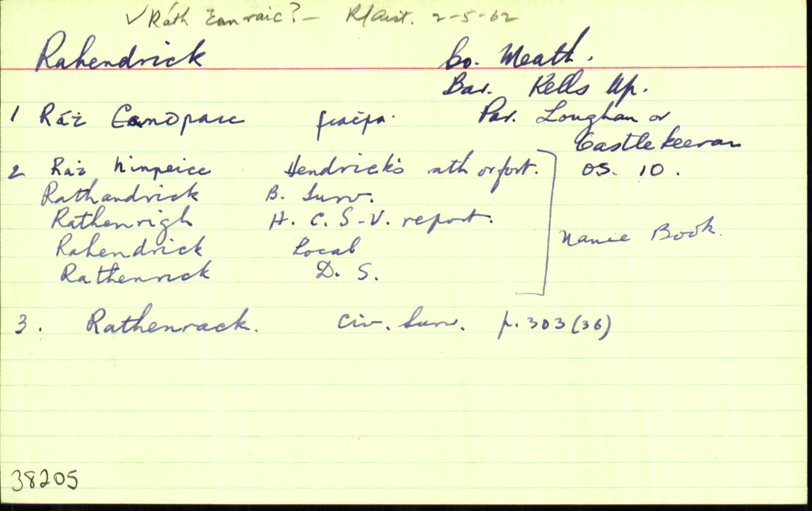
Rahendrick
(English)
Hierarchy
county
barony
civil parish
Centrepoint
53.7648, -6.97391latitude, longitude
Irish Grid (with letter)
Computing...
Irish Grid (without letter)
Computing...
Irish Transverse Mercator (ITM)
Computing...
Archival records
Historical references
| 1540-1 |
Rathenry
[Priory or hospital of St. John near Kellys]
|
|
| 1616 |
Rath-henricke
Grant…to Edw. Dowdall of Rathmore, esq…Maperath, Loghanston, Moate, Rath-henricke, Montanpole, Bardenaghe, and Fegatte…were held as of the manor of Belgree… the towns and lands of Cryvagh and Owtfold… CPR 309
|
|
| 1629 |
Rathhewricke, Rathenrick
Edw’ Dowdall fuit seos’ de maner’ de Belgree… Inq.CI 48
|
|
| 1637 |
Rahenrick
Jac’ Mape, nup de Maperath, seis’ fuit …vil’… de Maperath, unde hamlet’ vocat’ le Mountaynepole…120 acr’, Cabragh…Moate, Curragh, Rahenrick, Cornesanse, Loghan & Bardynagh… obit 40 an’ elaps. Gerrald’ Mape est ejus fil’ & her’…fuit etat’ 3 annor’ tempore mortis pris sui, & non maritat’ Inq.CI 139
|
|
| 1638 |
Rathenrick
Gerrald’ Pluncket de Drombaragh pcell’ ter’ vocat’ Skurlog’s land, Gerrald’ Pluncket, in mortag’, de vil…de Moate, Curragh, Rathenrick, Cabragh, Cornesanse & Loghan…qu’ tenuit a Gerrald’ Mape de Maperath…vil’…de Destenrath…
Maner’ de Killallon, Tulchanoge, Clonmaduffe & Kilsker… maner’ de Rathregan…in Moate, Curragh, rathenrick, Cabragh, Cornesanse, Loghan, Drumbaragh, Scurlog’s land & [ ] Inq.CI 137
|
|
| 1654 |
Rathenrack, Rathenricke, Rathenrick
Garrald Mape of Maperath, Irish Papist. <br>
Bounded on the East with the Curragh, Cornecause, Clonfenan & the Mote, on the west with the lands of Dervy, on ye north with…Cavan, & on th South with Moynleeh & the Blackwater. CS V 303
|
|
| 1655-7 |
Rathenricke
|
|
| 1655-7 |
Rathenrick
Garret Mape Ir: pap:
|
|
| 1660c |
Rathenricke
Garrett Mape, I.p. 86.
|
|
| 1668c |
Rathiurick
1- JAMES STOPFORD esq.—
Killy, 203… A[r]rdnaman…Castlekarran, 169 a…and Castlepole, 111 a. to be both called Stopford—Rathiurick, 197 a…Fagatt, 122a…Wm. Gouldings part in Boultowne als. Balltowne,
207a..Cabragh, 219 a…Loughan, 197a…Minleagh, 121 a…
Douore (part) and Donorebegg (part), 86 a…Carrick, 157 a…Crevie, 35 a.; bar Kells…
Milltowne (part), 135 a…bar. Ratoath ASE 182
|
|
| 1685c |
Rathenrik
|
|
| 1769 |
Rathenrick (Daniel [Farrelly])
Daniel [Farrelly], Rathendrick, co. Meath,
farmer. <br> Prerogrative Wills 163
|
|
| 1836 |
Rathenrick
|
DS:AL Leathanach: Mí070,22
|
| 1836 |
Rath Hineirce, 'Hendrick's rath or fort'
|
OD:AL Leathanach: Mí070,22
|
| 1836 |
Rath hineirce
|
pl:AL Leathanach: Mí070,22
|
| 1836 |
Rathandrick
|
BS:AL Leathanach: Mí070,22
|
| 1836 |
Rathenrigh
|
HCSV:AL Leathanach: Mí070,22
|
| 1836 |
Rathendrick
|
Larkin (Mí):AL Leathanach: Mí070,22
|
| 1836 |
Rahendrick
|
Agent & Cess Coll. (Dyas):AL Leathanach: Mí070,22
|
| 1836 |
Rahendrick
|
Local:AL Leathanach: Mí070,22
|
| 1836 |
Rahendrick
|
OD:AL Leathanach: Mí070,22
|
| 1836 |
[Rahendrick]
"It contains two forts."
|
Desc. Rem.:AL Leathanach: Mí070,22
|
Please note: Some of the documentation from the archives of the Placenames Branch is available here. It indicates the range of research contributions undertaken by the Branch on this placename over the years. It may not constitute a complete record, and evidence may not be sequenced on the basis of validity. It is on this basis that this material is made available to the public.
Archival and research material provided on this site may be used, subject to acknowledgement. Issues regarding republication or other permissions or copyright should be addressed to logainm@dcu.ie.