Hierarchy
county
barony
civil parish
townland
Kilmacowen
(English)
Centrepoint
54.2261, -8.51557latitude, longitude
Irish Grid (with letter)
Computing...
Irish Grid (without letter)
Computing...
Irish Transverse Mercator (ITM)
Computing...
Archival records
Historical references
| 1419 |
the perpetual vicarage of Kyllmacuagyn
VII 103-113
|
|
| 1420 |
perpetual vicarage of Kyllmacnagyn
|
|
| 1482‒3 |
Cillmacnagyn
|
CPL Leathanach: xiii 1471‒84 2 814
|
| 1585 |
Kilvacuan, Kilmacowen
|
Exch. E:Wood-Martin I Leathanach: 399
|
| 1605 |
Kilvickowen
|
CPR Leathanach: 70a
|
| 1655–7 |
Killmcowen Parish, Rossborne (leathchuid de bf. Kilmacowen), KillmcOwen
|
|
| 1660c |
Killmcowen
|
BSD Leathanach: 82
|
| 1665c |
Kilmacowen
|
HMR Leathanach: 66
|
| 1665c |
Kilmacowen
|
HMR Leathanach: 28, 38, 39
|
| 1685c |
Kil mc owen, K:mcOwen
|
|
| 1723 |
Killmc owen
|
CGn. Leathanach: 40.48.24181
|
| 1749 |
Kilmakowen
|
Cen. of Elphin Leathanach: 550
|
| 1812 |
Killmacowen & RossBeirne
|
CGn. Leathanach: 650.27.444640
|
| 1819 |
Killmakeon
|
|
| 1836 |
Cill Mhic Eóghain, 'church of the sons of Owen'
|
OD:AL Leathanach: Sl030,12
|
| 1836 |
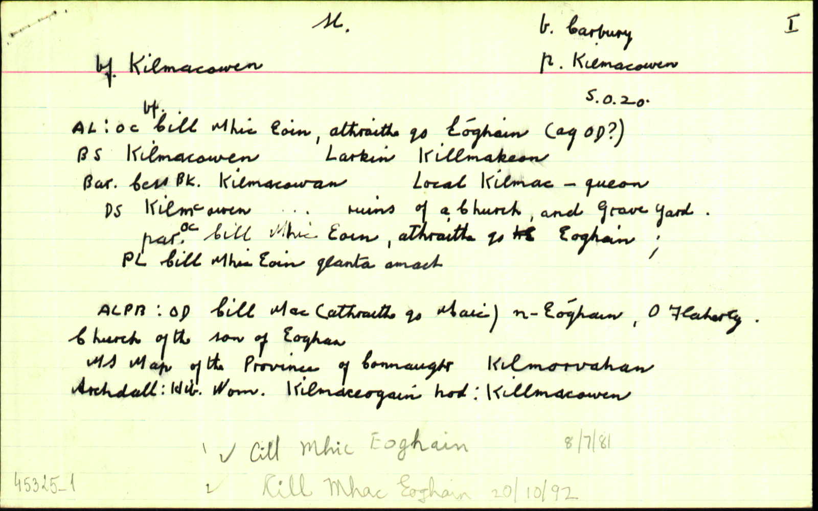
[Kilmacowen]
"The ruins of a church and grave yard are situated near its northern boundary. There is an old fort near the centre of the townland and a holy well called 'Tubberpatrick' N.E. of the old church" [Desc. Rem.];
|
Desc. Rem.:AL Leathanach: Sl030,12
|
| 1836 |
Killmakeon
|
Larkin Map:AL Leathanach: Sl030,12
|
| 1836 |
Kilmakeoin
|
BM:AL Leathanach: Sl030,12
|
| 1836 |
Kilmacowan
|
Bar. Cess Bk.:AL Leathanach: Sl030,12
|
| 1836 |
Kilmac-queon
|
Local:AL Leathanach: Sl030,12
|
| 1836 |
K'mcOwen
|
Cooper Map:AL Leathanach: Sl030,12
|
| 1836 |
Kilmcowen
|
DS Ref.:AL Leathanach: Sl030,12
|
| 1836 |
Kilmacowen
|
OD:AL Leathanach: Sl030,12
|
| 1836 |
Cill mhic eoin:
|
dúch (scriosta):AL Leathanach: Sl030,12
|
| 1836 |
Killmacowen
|
BS:AL Leathanach: Sl030,12
|
| 1836 |
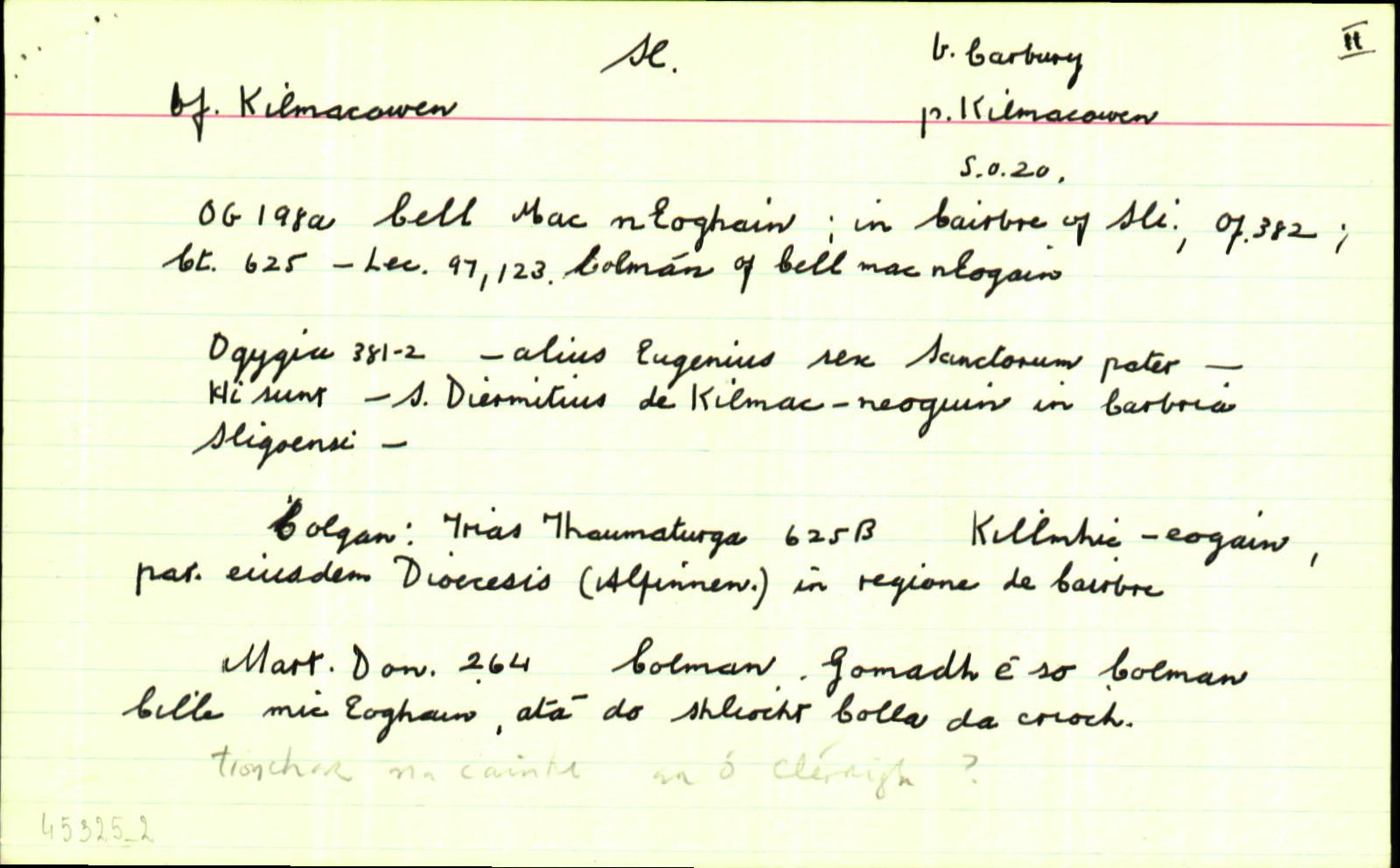
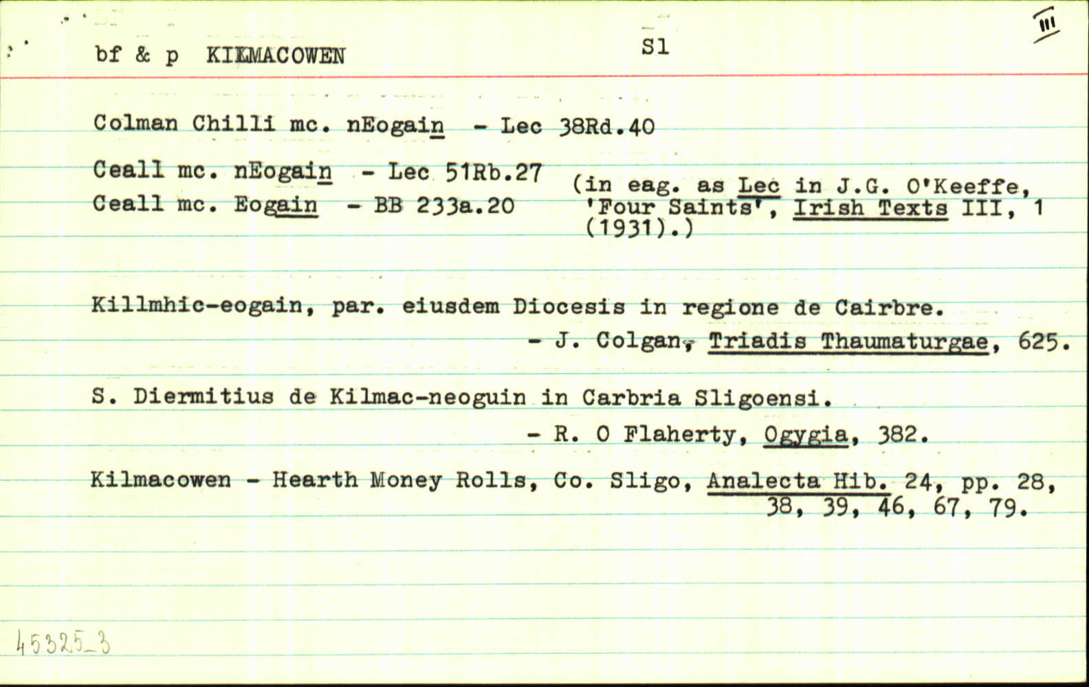
Cill Mhic Eoin (Eóghain) i.e., Cella filii Eugenii... In the Townland of Kilmacowen is an old Church in ruins, called Teampull Cille Mhic Eóin, at which there is a well called Tobar Patraic... At this well there is a stone having on it the impression of Saint Patrick’s knee, and retaining on it apparently the Saint’s blood, as the people think, from its presenting a red (rust-like) hue. A to the Saint under whose patronage this Parish is, I could get no information.
|
LSO (Sl) Leathanach: 60
|
| 1836 |
Killmacowen
|
BS:AL Leathanach: Sl030,12
|
| 1836 |
Kilmacowan
|
|
| 1836 |
Kilmakeoin
|
|
| 1836 |
K'mcOwen
|
|
| 1836 |
The ruins of a church and grave yard are situated near its northern boundary. There is an old fort near the centre of the townland and a holy well called “Tubberpatrick” N.E. of the old church
|
|
| 1836 |
Kilmcowen
|
|
| 1836 |
Cill mhic eoin:
|
|
| 1836 |
Killmakeon
|
|
| 1836 |
Kilmac-queon
|
|
| 1836 |
Kilmacowen
|
|
| 1836 |
Cill Mhic Eóghain “church of the sons of Owen”
|
|
| 1858 |
the lands of Killmacowen ors. Kilmacowen and Rossbern
|
CGn. Leathanach: 1858.13.21.336
|
| 1938 |
Cill Mac n-Eoin
|
Elphin PN Leathanach: 55
|
Please note: Some of the documentation from the archives of the Placenames Branch is available here. It indicates the range of research contributions undertaken by the Branch on this placename over the years. It may not constitute a complete record, and evidence may not be sequenced on the basis of validity. It is on this basis that this material is made available to the public.
Archival and research material provided on this site may be used, subject to acknowledgement. Issues regarding republication or other permissions or copyright should be addressed to logainm@dcu.ie.
Permanent link
https://www.logainm.ie/45325.aspxFurther information about this place
Folklore
The National Folklore Collection (dúchas.ie) contains material related to this place: