Hierarchy
county
barony
civil parish
townland
subunits
civil parishtownland
Kilgeever
(English)
Explanatory note
Centrepoint
53.761, -9.76696latitude, longitude
Irish Grid (with letter)
Computing...
Irish Grid (without letter)
Computing...
Irish Transverse Mercator (ITM)
Computing...
Archival records
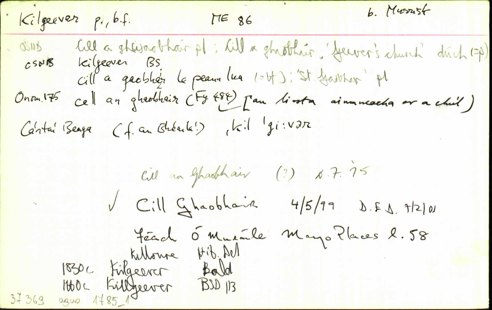
Historical references
| 1307c |
Kilgovir
|
Pap. Tax. Leathanach: 198
|
| 1440 |
Kyllgaybayt, Quarte de
|
CPL Leathanach: ix 139
|
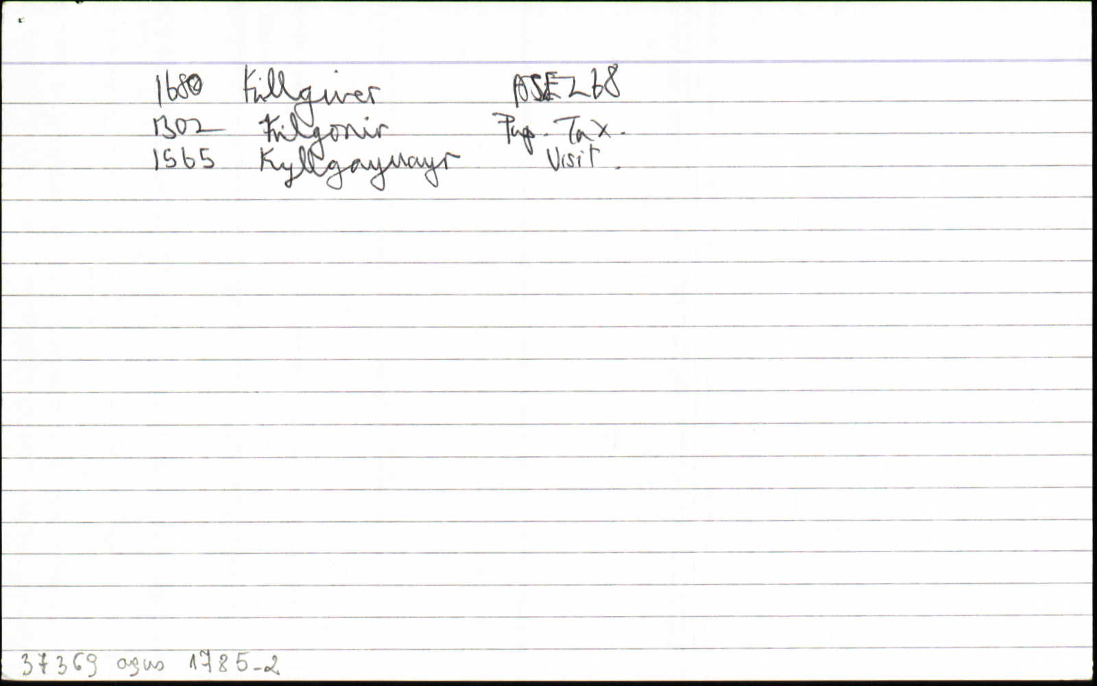
| 1481 |
Kylgacuayr, [John Oculean... of]
|
CPL Leathanach: xiii 765
|
| 1515 |
Villgaiphair
|
CPL Leathanach: xx 262 §358
|
| 1565c |
Kyllgayuayr, Vicaria de
|
Vis.Clonf. Leathanach: 153
|
| 1565c |
Kyllgayvayr
|
Vis.Clonf. Leathanach: 207
|
| 1574 |
Kylgavyr
|
Div. Conn. Leathanach: 2A (Knox) 216
|
| 1591 |
Kilgevur
|
Incumbents Leathanach: 224, 226
|
| 1617 |
Kilgeyovare
|
Inq.(ME) Leathanach: II.269
|
| 1620c |
Kilgeever
|
Westport Est. Pap. Leathanach: 40,889/5(12)
|
| 1622 |
Kilgeever
|
Westport Est. Pap. Leathanach: 40,889/5(17)
|
| 1635 |
Kilgower, the qr of
|
Straff. Inq. ME Leathanach: §52
|
| 1635 |
Kilgower, the qr of
|
Straff. Inq. ME Leathanach: §52
|
| 1661 |
(?)Killgeever Gleabe
|
BSD (ME) Leathanach: 111
|
| 1661 |
Killgeever Qr
|
BSD (ME) Leathanach: 113
|
| 1661 |
Kilgeever, Killgeever Parish
|
BSD (ME) Leathanach: 108, 111
|
| 1672c |
Killoure, Killgure
|
|
| 1680 |
par. Killgiver
|
ASE Leathanach: 268.14
|
| 1700c |
Kil[]ver
|
Conn. Map Leathanach: 2
|
| 1710 |
Kilgiver, the parish of
|
Westport Est. Pap. Leathanach: 40,918/3
|
| 1710c |
Killgver Parish [sic]… Killgiven… Kilgivere Parish
|
CRL Leathanach: 2A.3.16, 90, 92
|
| 1710c |
Killygeveor 1 qr
|
CRL Leathanach: 2A.3.16, 92
|
| 1715c |
Kilgure
|
|
| 1720c |
Kilgure
|
|
| 1721 |
Killour
|
|
| 1776 |
Kilgiver Parish
|
Mackenzie Leathanach: xiv
|
| 1792 |
Kilgivour
|
|
| 1792 |
Killgower Parish
|
QRL Leathanach: 2A.6.74, 181
|
| 1792 |
Killgver Parish [sic]... Killgiver
|
QRL Leathanach: 2A.6.74, 181, 183
|
| 1792 |
Killgeveor
|
QRL Leathanach: 2A.6.74, 182
|
| 1802 |
Kilgivour
|
|
| 1812 |
Kilgeever
|
|
| 1830 |
Kilgeever
|
Bald Uimhir: 17
|
| 1830 |
Kilgeever
|
TAB Leathanach: 47
|
| 1830 |
Kilgeever
|
TAB Leathanach: 47
|
| 1833 |
Kilgeever
|
Knox Hist. Tuam Leathanach: 189
|
| 1837 |
Gilgavower or Kilgever
|
Top. Dict. Leathanach: ii 97
|
| 1838 |
Kilgeever
|
BS:AL Leathanach: ME089,8
|
| 1838 |
Kilgeever
|
Rent Office:AL (ME) Leathanach: ME089,8
|
| 1838 |
Kilgewer
|
Strafford:AL Leathanach: ME089,8
|
| 1838 |
Cill a' Ghaobhair, 'Geever's church'
|
OD:AL Leathanach: ME089,8
|
| 1838 |
Cill a gaobhair/ St. Gaobhar/ Tobair na sal, 'strong water, scotchman'
|
pl:AL Leathanach: ME089,8
|
| 1838 |
Kilgeever
|
OD:AL Leathanach: ME089,8
|
| 1838 |
[Kilgeever]
"There is 1 old church in ruins, there is a graveyard and holy well called 'Tubber Ree-an-Donach' or King's holy well…"
|
Desc. Rem.:AL Leathanach: ME089,8
|
| 1838 |
Kilgeever
|
|
| 1838 |
Cill a Ghaobhair ‘church of St. Geever’
|
LSO [ME] Leathanach: §467
|
| 1838 |
Cill Ghaobhair ‘Geever’s church’
|
Please note: Some of the documentation from the archives of the Placenames Branch is available here. It indicates the range of research contributions undertaken by the Branch on this placename over the years. It may not constitute a complete record, and evidence may not be sequenced on the basis of validity. It is on this basis that this material is made available to the public.
Archival and research material provided on this site may be used, subject to acknowledgement. Issues regarding republication or other permissions or copyright should be addressed to logainm@dcu.ie.
Permanent link
https://www.logainm.ie/37369.aspxFolklore
The National Folklore Collection (dúchas.ie) contains material related to this place: