Hierarchy
county
barony
civil parish
townland
townland
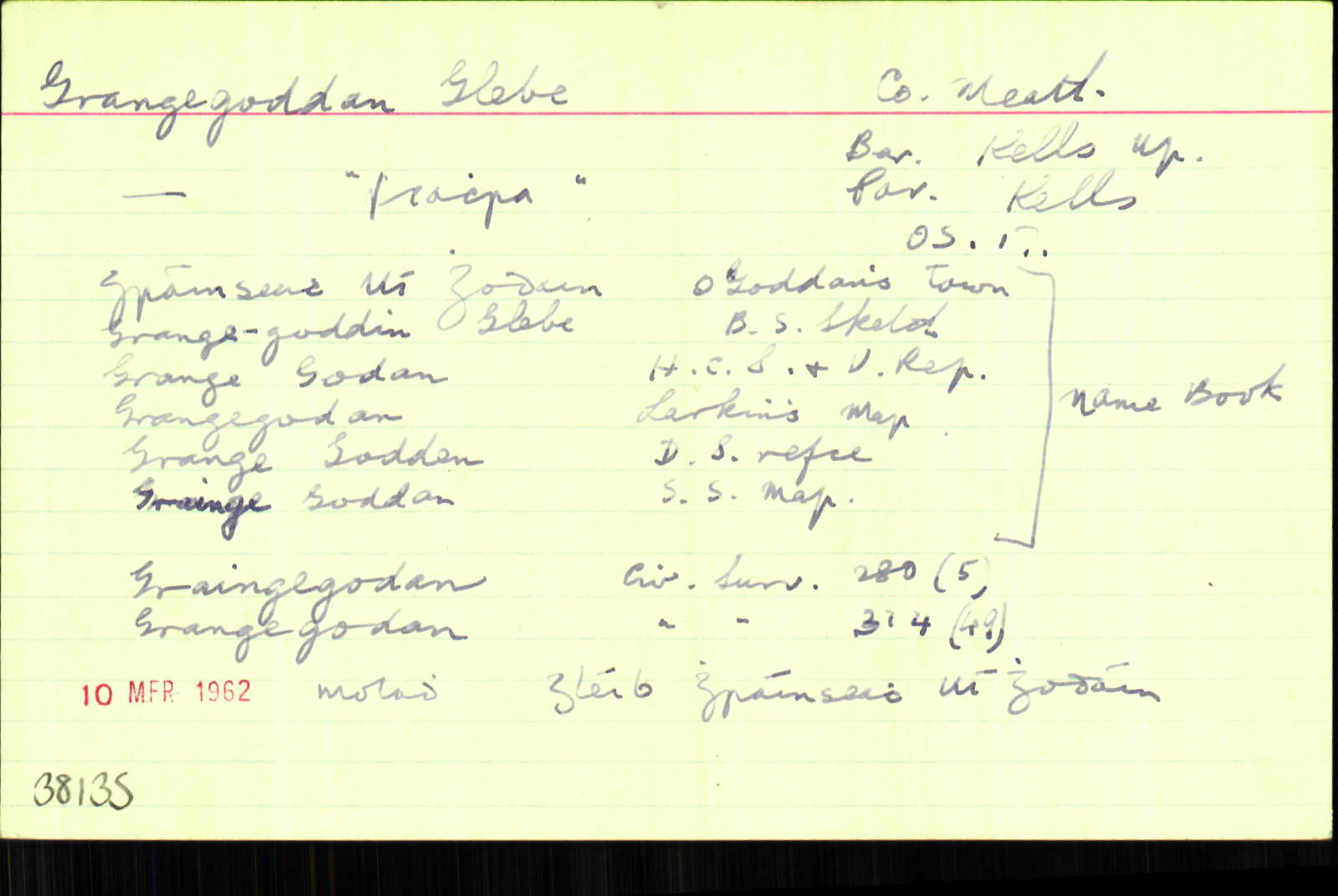
Grangegoddan Glebe
(English)
Hierarchy
county
barony
civil parish
Centrepoint
53.7065, -6.87104latitude, longitude
Irish Grid (with letter)
Computing...
Irish Grid (without letter)
Computing...
Irish Transverse Mercator (ITM)
Computing...
Archival records
Historical references
| 1415 |
Grange Godan
Patent Roll 3 Henry V <br>
Dublin
COMMISSION, by mainprize of Thomas Walleys of co. Dublin and Robert Babe of co. Louth, to John Young of custody of messuages, lands and tenements that belonged to William Young, archdeacon of Meath, in Personestoun Graunge, Colinestoun, Grange Godan and Balyrath in co. Meath, (Cal. ICR (chancery.tcd.ie))
|
|
| 1415 |
Graungegoddan
Patent Roll 2 Henry V <br>
COMMISSION, by mainprize of Ranulph Merbury and Alexander Henshall of co. Dublin, to Laurence Merbury kt of custody of all messuages, lands [etc.] in Personestoun, le Graunge, Colmestoun, Graungegoddan and Balyrath, which lately belonged to the abbot of the Blessed Mary of Kells, co. Meath (Cal. ICR (chancery.tcd.ie))
|
|
| 1619 |
Grangegaddane
Grant… to And. Dikes, merch… a Castle in Trim, lately Rob. Scorlock’s, merch…. Blind-street, Dondery and Irishtown, ... Farrell-street in Kells, Shiffock lane, Ovanan-street, Cross-street, St John’s –street, Maudlen-street, in the Boynaghes, in the town of Kells, Crostierre in Kells; the rood-park, Grangegaddane to Ledwiche-cross, Cloghranmore, Cnockbane, the parish of St John’s in Kells; in Carike and Carikegeit, Chineday and Coulanmeg, Cowlinalvaw in Kells, a road called a bother leading to the Crossmill; the Maudlen land; near the Cawsay leading to Corbentstown, near the Grange of Rossemed, two bothers to Faynstown, lately parcel of the chantry lands of the church of St Colombe in Kells, Galmolie’s farm ...CPR 431
|
CPR Leathanach: 431
|
| 1654 |
Grange godan
279
|
CS V Leathanach: 279
|
| 1654 |
Grangegodan
The said Usher [Archdeacon of Meath] <br>
Bounded on the east with…Gardenrath, on the west with …Phebog, on the north with…Kells, on the South with…Cookestowne.
CS V 314
|
CS V Leathanach: 314
|
| 1655-7 |
Grange Goddan
Léirithe mar fhearann eaglasta (+).
|
|
| 1655-7 |
Grainge Goddan
Archdeacons Land (+)
|
|
| 1660c |
Grange Godden
Arch Deacons. 74.
|
BSD Leathanach: 74
|
| 1685c |
Gronglada [sic]
|
|
| 1836 |
Grangegodden
|
Local:AL Leathanach: Mí047,11
|
| 1836 |
Grange Godden
|
DS Ref.:AL Leathanach: Mí047,11
|
| 1836 |
Grainge Goddan
|
DS Map:AL Leathanach: Mí047,11
|
| 1836 |
Gráinseach Ui Ghodain, 'O'Goddan's town'
|
OD:AL Leathanach: Mí047,11
|
| 1836 |
Grange-Goddan etc.
|
OD:AL Leathanach: Mí047,11
|
| 1836 |
Grangegoddin Glebe
|
BS:AL Leathanach: Mí047,11
|
| 1836 |
Grange Godan
|
HCSV:AL Leathanach: Mí047,11
|
| 1836 |
Grangegodan
|
Larkin (Mí):AL Leathanach: Mí047,11
|
| 1836 |
Grangegodden
|
Agent & Cess Coll. (Dyas):AL Leathanach: Mí047,11
|
Please note: Some of the documentation from the archives of the Placenames Branch is available here. It indicates the range of research contributions undertaken by the Branch on this placename over the years. It may not constitute a complete record, and evidence may not be sequenced on the basis of validity. It is on this basis that this material is made available to the public.
Archival and research material provided on this site may be used, subject to acknowledgement. Issues regarding republication or other permissions or copyright should be addressed to logainm@dcu.ie.