Hierarchy
county
barony
civil parish
townland
townland
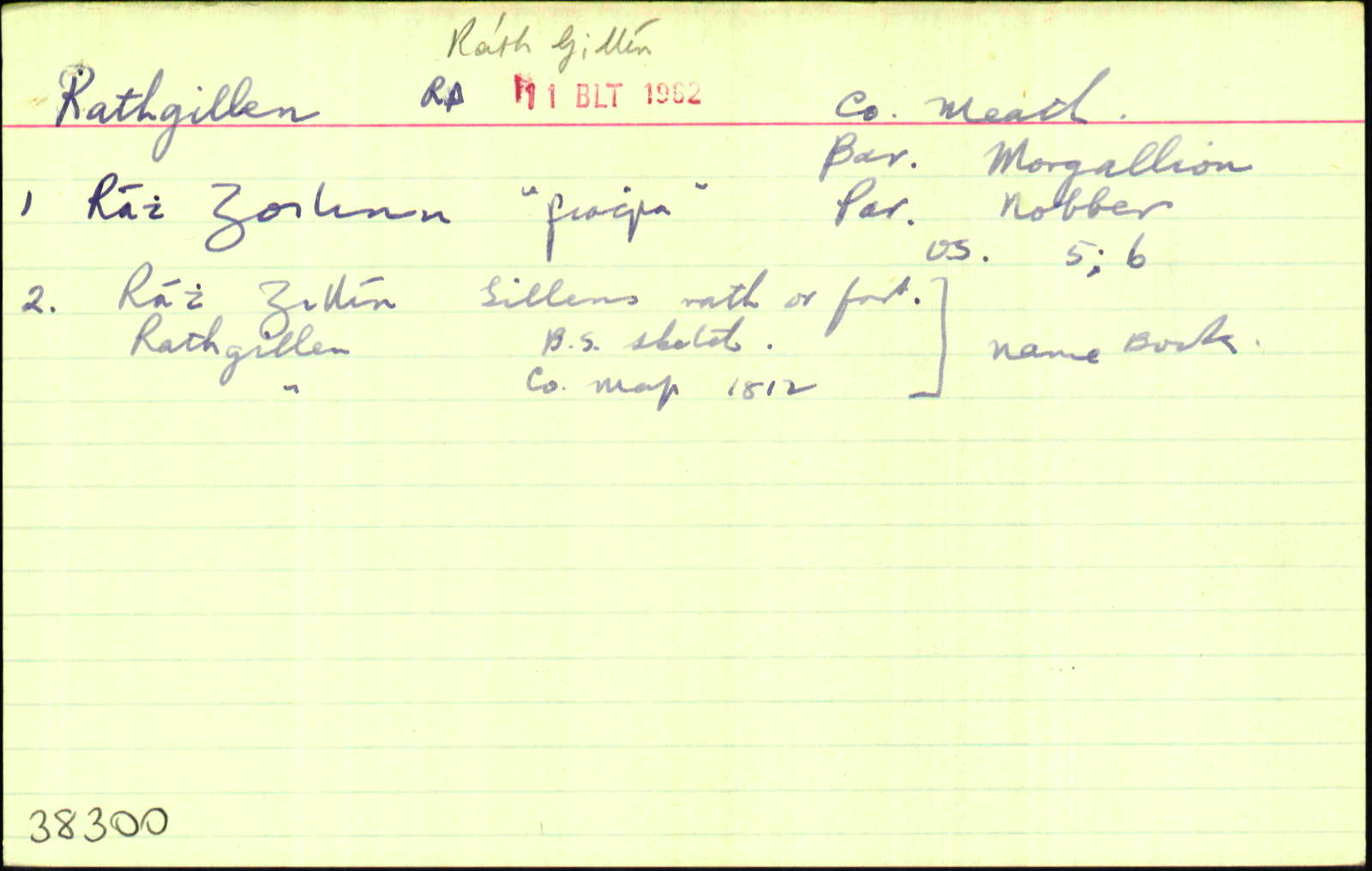
Rathgillen
(English)
Centrepoint
53.8351, -6.74506latitude, longitude
Irish Grid (with letter)
Computing...
Irish Grid (without letter)
Computing...
Irish Transverse Mercator (ITM)
Computing...
Archival records
Historical references
| 1667 |
Rathglihane
51. GEORGE BRIGSTOCK…the manor, town, and lands of Nobber, Spiddall, the 2 Garmanaghes, Moyhand the Woods, Little Nobber, Rathglihane, and Leonenace, 1 ,884…Sellersooke,
170 a…Kilbride, 264 a…Cammock, 84 a…Cloghreagh,
8 poles, 669 a…Tarmon, 8 poles,
800 a…the mill of Oldtowne…chief rent out of Ardmaghbregagh…Cregg;
bar. Morgallen, co. Meath—
Total quantity in co. Meath, 5,554 a…
ASE 99
|
|
| 1776 |
Rath Gillian
Anthony Preston Lord Viscount Gormanstown ... the Nobber Estate that is to say all those Lands and Hereditaments known and destinguished by the name of Garmanagh Lauffin upper Garmanagh Holestown Colledge Lurginagh Mullinagree Clogreagh and Mullin[ ] [Polemurrary?] Derrigmason Carretobber Killatymore Killa[ ] Coumak[ ] ... Whitewoods and Muff Rath Gillian Sellersook Camoge Killbride Spiddall Sloanstown Ardinagh Rowlagh Kilnalun Dunhida the Mill and Mill Lands [Leartagh?] ... upper and lower Ballanamore and Nobber ... Armagh Bregagh and Mullagh ... Morgallion
|
CGn. 312.89.207466
|
| 1781 |
Rathgillian
Gormanagh ... Lauffin ... Upper Germanagh Hollestown College ... Lurgenagh Mullenagree Cloghreagh ... Mullandrum & Polammay ... Dorigmason Caritobber and Killatymore ... Cournahave and Courleeah ... White Wood ... Muff ... Rathgillian ... Camoge ... Killbride ... Spiddull ... Killnalunn and Dunhida ... Loarlagh ... Culletagh ... upper and lower Ball[e?]namore
|
CGn. 339.93.227094
|
| 1812 |
Rathgillen
|
|
| 1826 |
Rathgillen
|
|
| 1836 |
Rathgillen
|
OD:AL Leathanach: Mí086,36
|
| 1836 |
Rathgillen
|
BS:AL Leathanach: Mí086,36
|
| 1836 |
Rathgillen
|
Co. Map 1812:AL Leathanach: Mí086,36
|
| 1836 |
Rath Gillín, 'Gillen's rath, or fort'
|
OD:AL Leathanach: Mí086,36
|
| 1836 |
[Rathgillen]
"…a fort called Rathcairn near its East side on a small hill. A hill called Mullaghbhu is in the N. W. of the townland…a place called Killawogy is in the N. E. of the townland…"
|
Desc. Rem.:AL Leathanach: Mí086,36
|
Please note: Some of the documentation from the archives of the Placenames Branch is available here. It indicates the range of research contributions undertaken by the Branch on this placename over the years. It may not constitute a complete record, and evidence may not be sequenced on the basis of validity. It is on this basis that this material is made available to the public.
Archival and research material provided on this site may be used, subject to acknowledgement. Issues regarding republication or other permissions or copyright should be addressed to logainm@dcu.ie.
Permanent link
https://www.logainm.ie/38300.aspxFolklore
The National Folklore Collection (dúchas.ie) contains material related to this place: