Hierarchy
county
barony
civil parish
electoral division
townland
townland
An Coinicéar
genitive: an Choinicéir
(Irish)
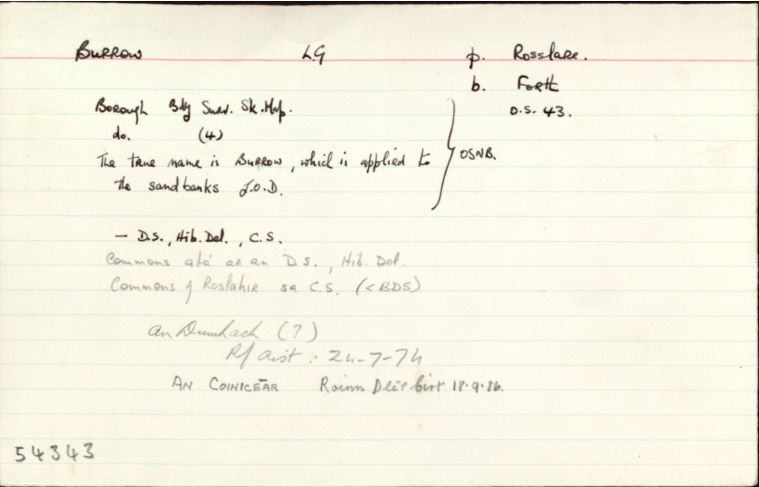
Burrow
(English)
Hierarchy
county
barony
civil parish
electoral division
Centrepoint
52.2971, -6.39533latitude, longitude
Irish Grid (with letter)
Computing...
Irish Grid (without letter)
Computing...
Irish Transverse Mercator (ITM)
Computing...
Archival records
Historical references
| 1660 |
Commons of Roslahir
|
BSD (LG) Imleabhar: (CS), Leathanach: 93 (307)
|
| 1685 |
Coms.
|
|
| 1725 |
Bunnyborough adjoining the Slobb
|
Loftus Papers Leathanach: 40
|
| 1725 |
Cunnyborough next to the slob with the slob from the Rosslare Cunnyborough to Woodtown point
|
Loftus Papers Leathanach: 40
|
| 1816 |
Sandhills
|
|
| 1840 |
[Burrow] "St. Breagh's Well is west side of townland. See page 40. Site of an old chapel in west side of townland."
|
Desc. Rem.:AL Imleabhar: 1, Leathanach: 10
|
| 1840 |
Borough
|
BS:AL Imleabhar: I, Leathanach: 10
|
| 1840 |
Borough
|
|
| 1840 |
Borough
|
|
| 1840 |
Borough
|
|
| 1840 |
Borough
|
|
| 1840 |
Burrow "The true name is 'Burrow' which is applied to the sandbanks." [Nóta OD]
|
OD:AL Imleabhar: 1, Leathanach (AL): 10
|
Please note: Some of the documentation from the archives of the Placenames Branch is available here. It indicates the range of research contributions undertaken by the Branch on this placename over the years. It may not constitute a complete record, and evidence may not be sequenced on the basis of validity. It is on this basis that this material is made available to the public.
Archival and research material provided on this site may be used, subject to acknowledgement. Issues regarding republication or other permissions or copyright should be addressed to logainm@dcu.ie.
Permanent link
https://www.logainm.ie/54343.aspxFurther information about this place
Open data
Application programming interface (API)
Available under
Creative Commons Attribution 4.0 International (CC BY 4.0)
API key required to access data
Linked Logainm
Formats: RDF | RDF N3 | RDF JSON | RDF XML
Operated by Digital Repository of Ireland